Storms Brewing to the West on this Memorial Day; Parts of Alabama Upgraded to Slight Risk
It’s been a quiet and humid Memorial Day morning across much of Central and North Alabama, but things are beginning to stir. Low clouds and patchy fog earlier today have given way to a mix of sunshine and clouds, with temperatures now rising through the 70s and 80s. Dewpoints remain high in the upper 60s to near 70, signaling a primed atmosphere. As of early afternoon, most of the state remains dry, but we’re watching developments to the west with increasing interest.
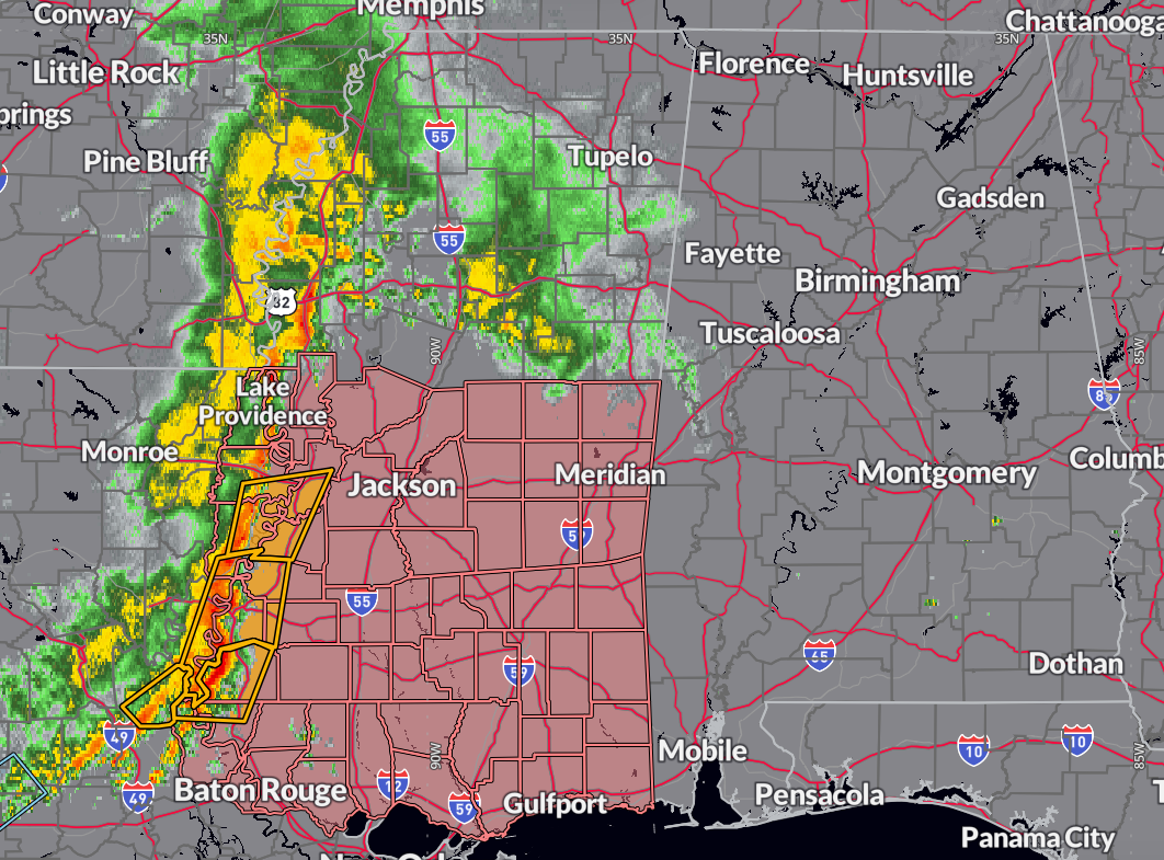
A well-organized complex of storms is pushing eastward out of Louisiana and Mississippi, anchored by a mesoscale convective vortex (MCV) that appears to be maintaining structure as it heads toward the Lower Mississippi Valley. Some models—especially the NAM family—suggest this MCV could play a key role later today and tonight across Mississippi and Alabama, either directly through storm initiation or by enhancing shear that could support supercell development. That’s a lower confidence scenario, but something that bears watching closely.
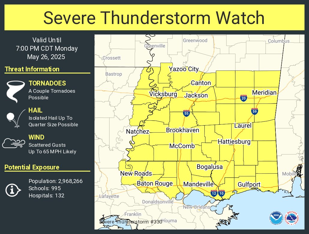
Meanwhile, additional thunderstorms are expected to develop ahead of the main line in response to diurnal heating and weak boundaries left over from prior convection. The best chances for scattered storms this afternoon will be across western and southern Alabama, where some breaks in the cloud cover have occurred. Any of these storms could produce hail and damaging winds, and localized flash flooding is possible where storms train over the same areas. A new Severe Thunderstorm Watch has just been issued for much of southern Mississippi and parts of southeastern Louisiana as the MCS continues to organize and move east. It’s possible parts of Alabama may be added later if the complex holds together.
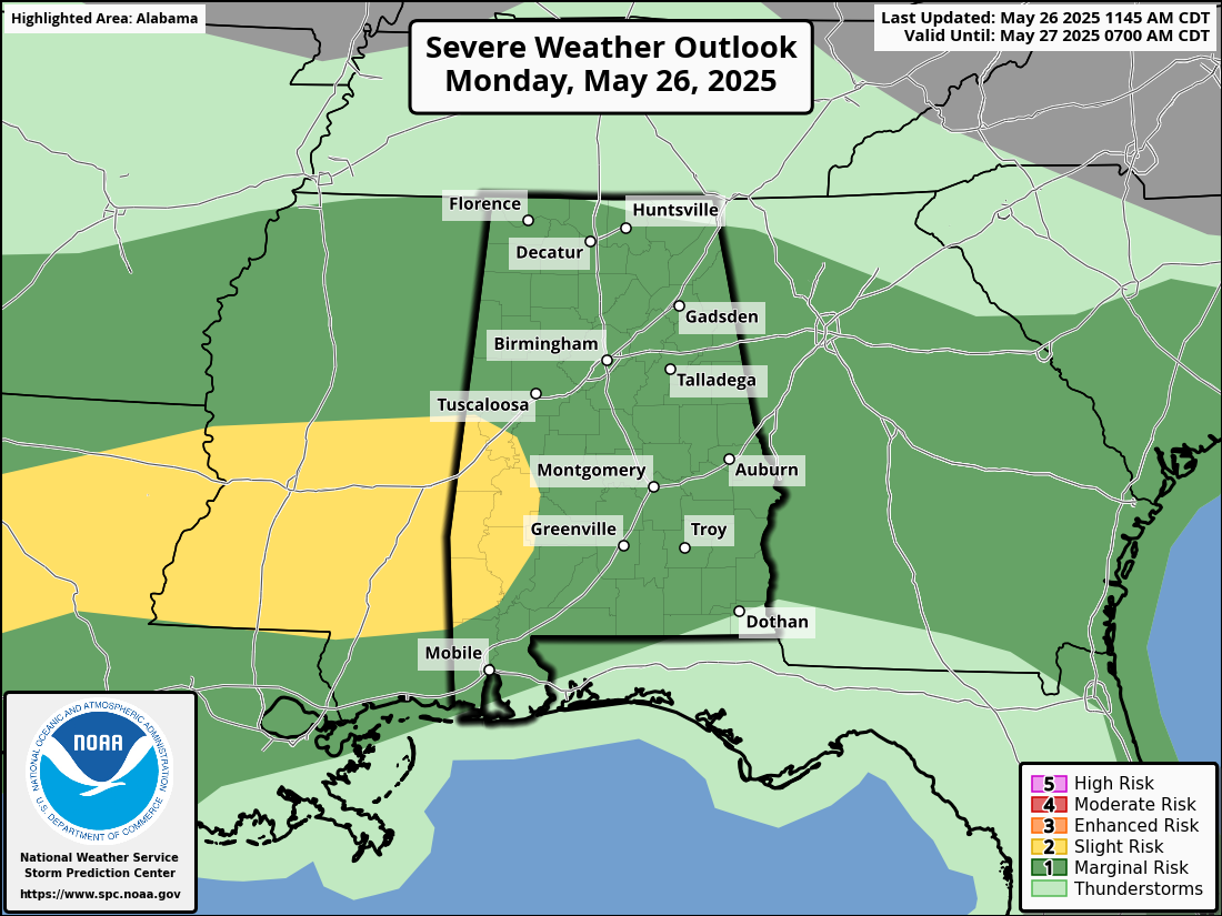
The Storm Prediction Center has upgraded portions of West Central Alabama to a slight risk (level 2 of 5) for severe storms later today. This includes portions of Sumter, Greene, Hale, Marengo, Choctaw, Washington, Clarke, and Wilcox counties. Farther north, most of Central Alabama remains under a marginal risk (level 1 of 5), with a continued threat of damaging wind gusts and hail through the afternoon and evening hours.
Looking ahead, the unsettled pattern remains locked in through midweek, with additional rounds of thunderstorms possible Tuesday and Wednesday. While the severe threat will vary each day, damaging winds, hail, and heavy rainfall will remain the primary hazards.
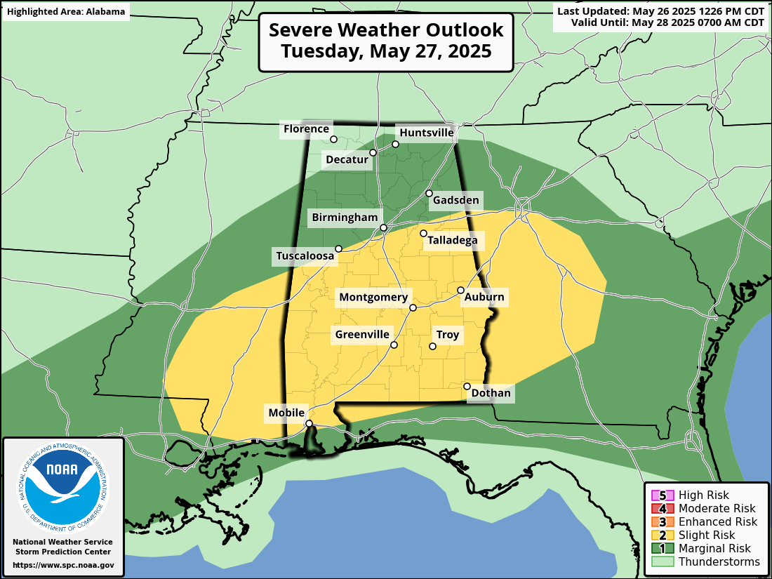
The Day Two severe weather outlook has been upgraded to a slight risk (level 2 of 5) for a large portion of Alabama on Tuesday, as conditions favor the development of strong to severe thunderstorms during the afternoon and evening hours. A remnant MCV from ongoing storms may ride along a stalled front across the region, enhancing storm organization and intensity. Damaging winds will be the primary threat, but some hail is also possible as storms cluster and track eastward through Mississippi and Alabama. The degree of the severe risk will hinge on how today’s storms shape the air mass going into Tuesday. Regardless, residents across central and southern Alabama should prepare for another round of potentially impactful weather.
Stay weather-aware, especially if you’re planning outdoor activities late today and into the evening.
Category: Alabama's Weather, ALL POSTS, Severe Weather, Social Media
About the Author (Author Profile)
Bill Murray is the President of The Weather Factory. He is the site's official weather historian and a weekend forecaster. He also anchors the site's severe weather coverage. Bill Murray is the proud holder of National Weather Association Digital Seal #0001 @wxhistorianSubscribe
If you enjoyed this article, subscribe to receive more just like it.


