Alabama Weather Update at 2:20 pm
Scattered thunderstorms are developing across North and Central Alabama this afternoon, forming earlier than expected due to the very moist and unstable environment. An upper-level disturbance moving through the Mississippi and Ohio Valleys is enhancing lift, helping initiate storms despite limited deep-layer shear. Storms are currently forming in clusters and may organize into broken lines, especially across west-central and northwestern parts of the state.
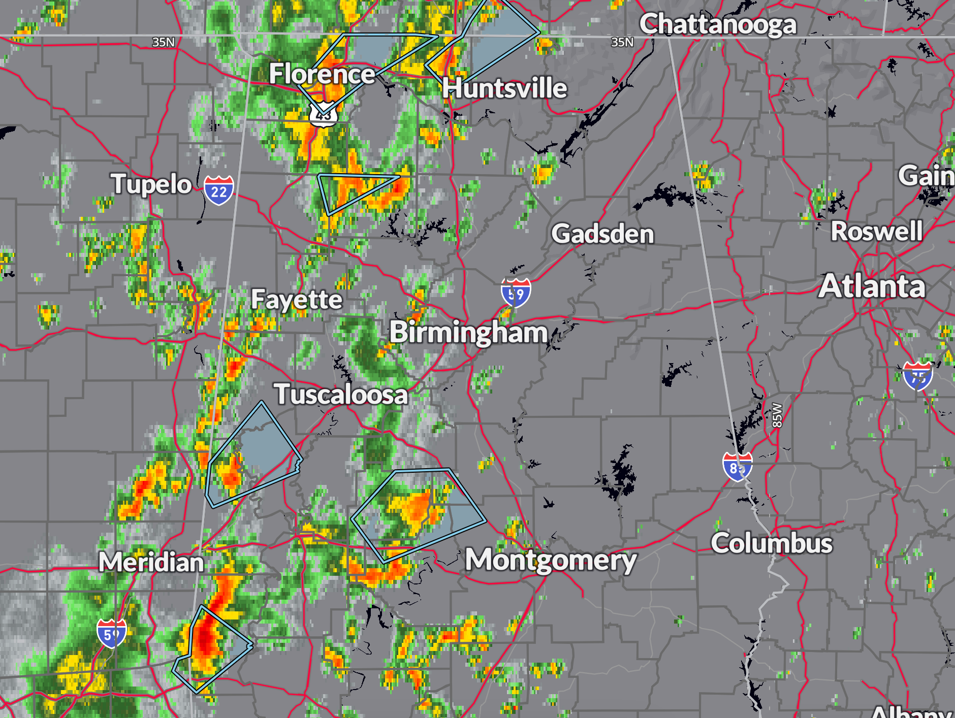
The strongest storms at this hour are over…
…Perry and Dallas counties from west of Valley Grande to near Orrville back into eastern Marengo County.
…In northern Sumter County north of Livingston County.
…In Choctaw County northwest and southwest of Butler.
…In northeastern Marion County into northwestern Winston County. This activity is along US-278 from northwest of Double Springs over to Addison.
…Near the Shoals in eastern Lauderdale and Colbert Counties.
…in Limestone County near Athens and Tanner. This cell will move into northwestern Madison County near Capshaw, Harvest, and Toney.
The primary threats with today’s storms will be localized damaging wind gusts and heavy rainfall. CAPE values between 1000 and 3000 J/kg combined with precipitable water values near 2 inches will allow for intense downpours that may cause temporary street flooding or ponding in low-lying areas. While the overall severe weather threat remains marginal, a few stronger storms could produce wind gusts over 50 mph and small hail. Some thunderstorm outflows may also stabilize the atmosphere locally, reducing risk in certain areas.
As we move into the evening hours, the coverage of storms should gradually decrease with the loss of daytime heating, though isolated activity could linger due to continued upper-level support. Conditions will remain warm and humid overnight, with lows in the mid 60s to around 70. Another round of scattered storms is expected Saturday afternoon as the mid-level trough continues eastward, and some of these could again be briefly strong.
At this time, the Storm Prediction Center does not anticipate issuing any severe weather watches, but mesoscale discussions highlight the potential for brief bowing segments and merging clusters that could enhance wind damage risk on a very localized basis. Stay weather-aware through the remainder of the day, especially if you’re outdoors, as dangerous lightning and brief downpours could disrupt activities across the region.
Category: Alabama's Weather, ALL POSTS, Severe Weather, Social Media
About the Author (Author Profile)
Bill Murray is the President of The Weather Factory. He is the site's official weather historian and a weekend forecaster. He also anchors the site's severe weather coverage. Bill Murray is the proud holder of National Weather Association Digital Seal #0001 @wxhistorianSubscribe
If you enjoyed this article, subscribe to receive more just like it.


