Sunday Weather Briefing Video: Steamy Days, Splashy Storms, and Some Tropical Potential
As we close out June and step into the heart of midsummer, the atmosphere is in no rush to go anywhere fast. Deep humidity, steamy afternoons, and slow-moving storms are the signature of this pattern—and it’s locked in for a while. While a true heat advisory isn’t warranted for today, the combination of upper 80s to near 90° temps and dewpoints in the 70s will push heat index values well into the 90s. At the same time, the lack of strong steering flow means that any storm that does develop could easily overstay its welcome, dumping buckets of rain on one spot while leaving others dry. And as a cold front tries to sag southward into the region this week, rain chances will go up and highs may edge down a bit—but the humidity isn’t leaving anytime soon. It’s a classic stagnant summer setup, and we’ll walk you through it from top to bottom.
STORMY SUNDAY AHEAD
A sticky start Sunday morning will give way to scattered to numerous showers and storms during the afternoon and early evening hours. Precipitable water values are near 2″, with CAPE values indicating instability the 2,000–3,000 J/kg range and very little wind shear. That means slow movers and tropical downpours are the main threats. Rain rates could exceed 2” per hour in some spots, especially in areas with cell training or boundaries left behind from Saturday’s storms. The heat will still be a factor, with highs in the upper 80s and heat index values just under 100°. While the lightning and gusty winds will grab your attention, localized flooding will be the issue to watch late in the day.
FRONT LURKING TO THE NORTH
A cold front now diving out of the Northern Plains will push into the Tennessee Valley early this week, increasing coverage and duration of showers and storms Monday through Wednesday. Expect high PoPs for Monday and Tuesday, in the 80-90 percent range. Highs will back off slightly into the mid 80s, but high dewpoints and slow-moving storms will maintain a soggy feel. The front may stall or decay near the state line, keeping flooding issues a concern. Gusty winds and frequent lightning will accompany the heavier cells.
LATE-WEEK TRANSITION
By Thursday and Friday, the front may slide a bit farther south, allowing a weak ridge to rebuild over the Southeast. That would result in slightly lower storm coverage—think scattered instead of widespread—but still daily storm chances due to instability and lingering boundaries. Temperatures should creep back into the upper 80s and low 90s by the end of the week, with heat index values back near triple digits. Dewpoints in the low 70s will make sure the air feels just as thick. Pretty typical weather for Fourth of July in Alabama!
NEXT WEEKEND: SUMMER NORMALS
Right now, there’s no strong signal for anything out of the ordinary as we move into the first weekend of July. With ridging near or just west of the region and enough Gulf moisture still in place, look for typical summertime fare: highs in the 90–93° range, isolated to scattered PM storms, and muggy nights in the 70s. Nothing organized, just hot and hazy with the occasional downpour.
VOODOO TERRITORY: MIDSUMMER STATUS QUO
Looking into week two, ensemble guidance favors weak ridging near the Southern Plains and a trough near the East Coast. That setup usually keeps Alabama in a hot and humid regime with daily “pop-up” storms—no fronts, no big heat waves, and no early cool snaps. The CPC outlook leans toward above-normal rainfall and near-normal temperatures, reinforcing the theme of wet afternoons and steamy evenings as July gets going.
SEVERE WEATHER OUTLOOK
While severe weather is not expected across Alabama on Sunday, a more active day is shaping up for the central U.S. A Slight Risk (level 2 of 5) exists from central Iowa to the western Upper Peninsula of Michigan. In this region, high instability and modest mid-level flow could allow for a large MCS to develop late Sunday into Sunday night with damaging winds and hail possible. Locally, strong storms in the Mid-Atlantic may produce wet microbursts, but organized severe weather appears unlikely across the Deep South.
TROPICAL UPDATE: BARRY, FLOSSIE, CHANTAL LATER THIS WEEK?
As of early this morning, Tropical Depression Two is centered in the western Bay of Campeche, steadily organizing as it tracks west-northwest toward the Gulf coast of Mexico. The system developed yesterday afternoon from Invest 91L after reconnaissance aircraft confirmed a closed circulation and increasing convection. It’s expected to strengthen into a tropical storm later today before making landfall tonight near or just north of Tuxpan, along the eastern coast of Mexico south of Tampico.
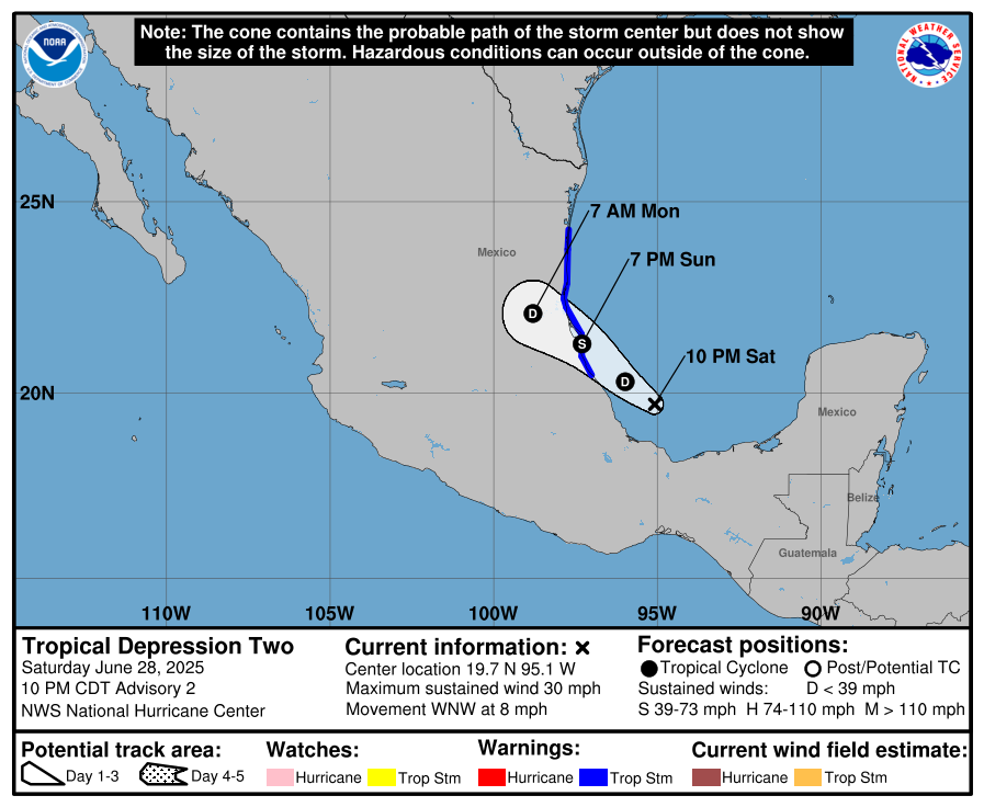
While the wind field remains modest, the primary concern continues to be heavy rainfall, with widespread totals of 3 to 6 inches and isolated pockets up to 10 inches forecast across parts of Veracruz, San Luis Potosí, and Tamaulipas. Flash flooding and mudslides are possible, particularly in hilly and mountainous terrain. A Tropical Storm Warning remains in effect from Boca de Catan to Tecolutla, where tropical storm-force winds could arrive by late afternoon. The system will weaken quickly over land and poses no threat to the U.S. Gulf Coast, but it marks the second tropical cyclone of the Atlantic season and reflects the ongoing need to monitor the southwest Gulf, where development can occur close to land with little lead time. A separate system in the Eastern Pacific (EP95) has a high chance of development, but it poses no threat to land at this time. When it gets a name, it will be Flossie.
With Invest 91-L expected to move inland over eastern Mexico by Monday, attention will quickly shift to the northeastern Gulf and Southeast U.S. coastline, where model guidance increasingly hints at the potential for tropical development late next week. A decaying front is forecast to stall in this region, creating a favorable setup for a low-pressure system to form and possibly organize into a tropical system from late week through next weekend. The GFS suggests development near the northeast Gulf with a westward drift toward the central Gulf Coast, while the Canadian favors a system forming near the Carolinas and racing out to sea. The ECMWF ensemble shows about a 40% chance of development near the Carolina coast, while the operational run is more subdued. At this range, forecast confidence is low—not just for if development occurs, but also where—but the environment will be moisture-rich either way, with potential for heavy rain from the northeastern Gulf through Florida and into the Southeast. Flooding could become a concern in places like the Florida Panhandle, the Big Bend, and Tampa Bay as the pattern unfolds.
BEACH FORECAST FOR THE BEAUTIFUL BEACHES OF ALABAMA AND NORTHWEST FLORIDA
It’s a dangerous weekend to be in the water, with a high risk of rip currents at nearly every stretch of beach along the Gulf. From Dauphin Island to Panama City and down through Apalachicola, surf heights will range from 2 to 3 feet, and the water is a bath-like 84–88 degrees. Showers and storms will be likely each day, especially in the late morning and afternoon hours. Expect highs in the mid to upper 80s, with dewpoints near 80 and heat indices above 100 in the sun. Be very cautious—heed local beach flags, stay near lifeguards, and keep an eye on the sky for the threat of lightning.
NATIONAL TEMPERATURE EXTREMES SATURDAY
116 at Death Valley, CA; 27 at Peter Sinks, UT
COMING UP ON WEATHERBRAINS
This Monday night at 7pm CDT on YouTube.com/WeatherBrains, we’re crossing the pond for a global perspective! Our guest is Lars Lowinski, joining live from Bonn, Germany. Lars is a veteran meteorologist with international experience in Europe and New Zealand, now working with WetterOnline to bridge their U.S. operations and German product development. He’s also a seasoned storm chaser and long-time WeatherBrains fan, tuning in since 2008. Join us for the conversation—and as always, you can stream the episode later at WeatherBrains.com or wherever you get your podcasts.
THIS DAY IN WEATHER HISTORY: JUNE 29, 2003
Tropical Storm Bill made landfall south of Houma, LA with top sustained winds of 60 mph, delivering a storm surge of six feet across coastal Louisiana. In Montegut, the town levee was breached for the second time in two years, resulting in significant flooding. Bill’s rains stretched from Louisiana to Alabama, dumping 5 to 8 inches across the region. A tornado spun up in Reserve, LA, injuring four people. The name “Wild Bill” proved apt for this early-season system that brought more flooding than wind.
Category: Alabama's Weather, ALL POSTS, Social Media, Tropical
About the Author (Author Profile)
Bill Murray is the President of The Weather Factory. He is the site's official weather historian and a weekend forecaster. He also anchors the site's severe weather coverage. Bill Murray is the proud holder of National Weather Association Digital Seal #0001 @wxhistorianSubscribe
If you enjoyed this article, subscribe to receive more just like it.


