Tropical Storm Chantal Forms off the Southeast coast—No Impacts Expected for Alabama
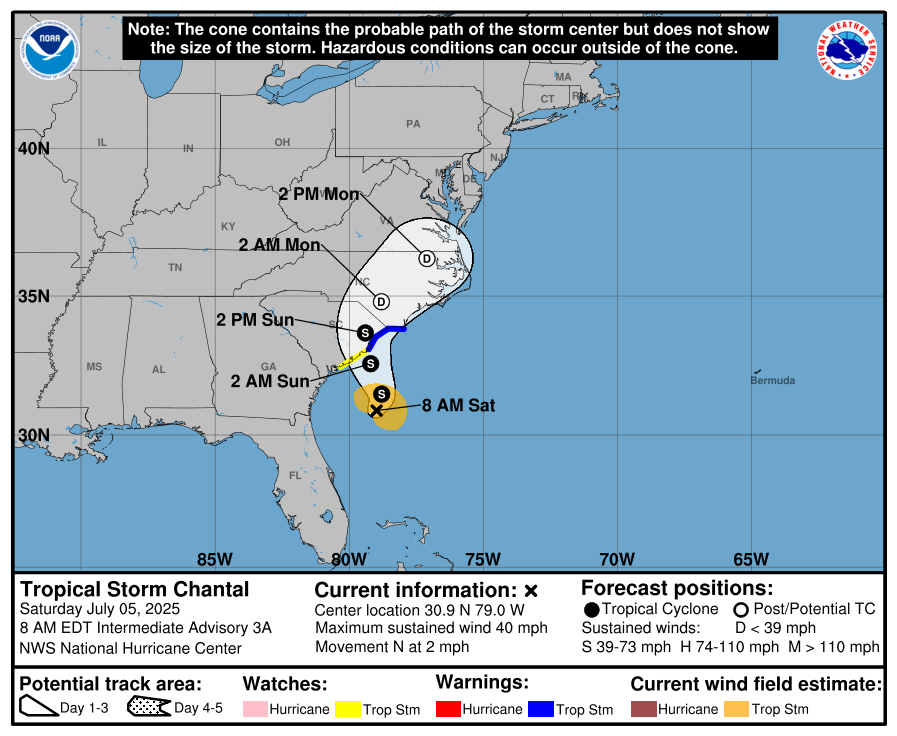
Tropical Storm Chantal officially formed this morning off the Southeast U.S. coast, about 150 miles southeast of Charleston, South Carolina. As of 7 a.m. CDT, maximum sustained winds were 40 mph and the storm was drifting slowly northward at just 2 mph. Tropical Storm Warnings are now in effect from the South Santee River in South Carolina to Cape Fear, North Carolina, with watches extending farther southwest to Edisto Beach.
Chantal is expected to gradually strengthen a bit more before making landfall in South Carolina Sunday morning. Tropical-storm-force winds extend outward up to 70 miles from the center, primarily to the east. The main threats will be heavy rain (2 to 4 inches, locally up to 6 inches), gusty winds, minor coastal flooding, and rough surf including dangerous rip currents. The system should weaken quickly after landfall and dissipate early next week.
There are no impacts expected for Alabama—Chantal will remain well to our east and will not influence our weather pattern. However, for those traveling to or vacationing along the Carolinas’ coast this weekend, conditions will deteriorate with hazardous marine conditions and the potential for flash flooding.
Category: ALL POSTS, Social Media, Tropical
About the Author (Author Profile)
Bill Murray is the President of The Weather Factory. He is the site's official weather historian and a weekend forecaster. He also anchors the site's severe weather coverage. Bill Murray is the proud holder of National Weather Association Digital Seal #0001 @wxhistorianSubscribe
If you enjoyed this article, subscribe to receive more just like it.


