July Sizzle Continues With A Few Rumblings On The Radar
Sorry, no video this morning due to an ongoing, huge project.
We’ve turned the corner into July’s second weekend, and the Southeast is feeling every bit of midsummer. The heat is firmly in place, the tropics have stirred with Tropical Storm Chantal, and the pulse of our typical summertime thunderstorm pattern is gradually revving back up. As we head into Sunday, subtle shifts in moisture and upper-level steering will lead to isolated storms in a few corners of Alabama, with more widespread action building back in by early next week. All the while, the beach remains hot and inviting—though not without its hazards—and the High Plains look active with severe weather. Let’s walk through what to expect.
QUIET START LOCALLY, BUT CHANGES LOOM ALOFT
An upper-level low over the Gulf of Mexico and a retrograding disturbance over Florida are subtly influencing Alabama’s weather pattern. At the surface, a diffuse frontal zone lingers from the Carolinas down into the Gulf, and while the main impact of Chantal will remain east of us, subsidence on its western flank has helped dry out much of Central and East Alabama. That said, there’s enough moisture and residual instability in the west and far southeast to warrant mention of isolated showers or storms today, especially where local convergence can build briefly. Temperatures will once again reach the mid 90s, with heat indices just below advisory thresholds. Winds remain light and terrain-driven for now.
SUNDAY BRINGS HEAT, HINTS OF MOISTURE RETURN
Sunday’s convection remains conditional and modestly confined. Models support two pockets where storm chances are slightly elevated: one in far west Alabama tied to leftover boundaries and convergence zones, and one in the far southeast closer to enhanced Gulf moisture. These PoPs remain in the 10–14% range and will not be mentioned prominently. Otherwise, expect hot and mostly dry conditions, with highs near 95 in most locations and lows in the upper 60s to low 70s Sunday night under mostly clear skies.
ACTIVE PATTERN NEXT WEEK AS MOISTURE BUILDS
By Monday, southerly flow begins to pull deeper moisture northward across the state. That, combined with a weak frontal boundary sagging southward from the Ohio Valley, will support better chances of scattered afternoon storms through the workweek. The midweek period may feature more robust thunderstorm coverage and perhaps a few strong downbursts each afternoon. Temperatures remain steady in the low to mid 90s, though higher dewpoints will increase heat indices into the 100–105° range by Wednesday and Thursday.
EYES ON THE WEEKEND FRONT
A front currently projected to stall well north of us by late Friday may begin inching southward next weekend, increasing rain chances slightly, especially for North Alabama. Confidence in timing remains low, but model agreement hints at some weakening of the ridge and increased convective activity near the Tennessee border. Otherwise, typical July conditions—hot, humid, and stormy in spots—will likely persist into next weekend.
PEEKING INTO WEEK TWO (VOODOO TERRITORY)
The extended range shows a familiar summertime setup: strong upper-level ridging rebuilding across the Southwest U.S., potentially sending more heat our way. Meanwhile, troughing over the eastern U.S. may dip south enough to reinforce frontal boundaries into the Deep South. This could translate into enhanced storm chances around July 11–13, especially if any stalled fronts linger. No organized severe weather signals are showing locally, but the pattern warrants continued attention as moisture surges remain likely.
SEVERE WEATHER OUTLOOK
The SPC highlights a Slight Risk (Level 2 of 5) for severe thunderstorms Sunday afternoon and evening across much of the central High Plains. This includes eastern Colorado, southeast Wyoming, western Nebraska, and northwest Kansas. Large hail up to 2 inches in diameter and damaging wind gusts over 75 mph are possible, especially with any evolving MCSs. Elsewhere, isolated strong storms may occur across the Carolinas (associated with Chantal), Maine, and the Midwest, but organized severe weather is not expected in Alabama.
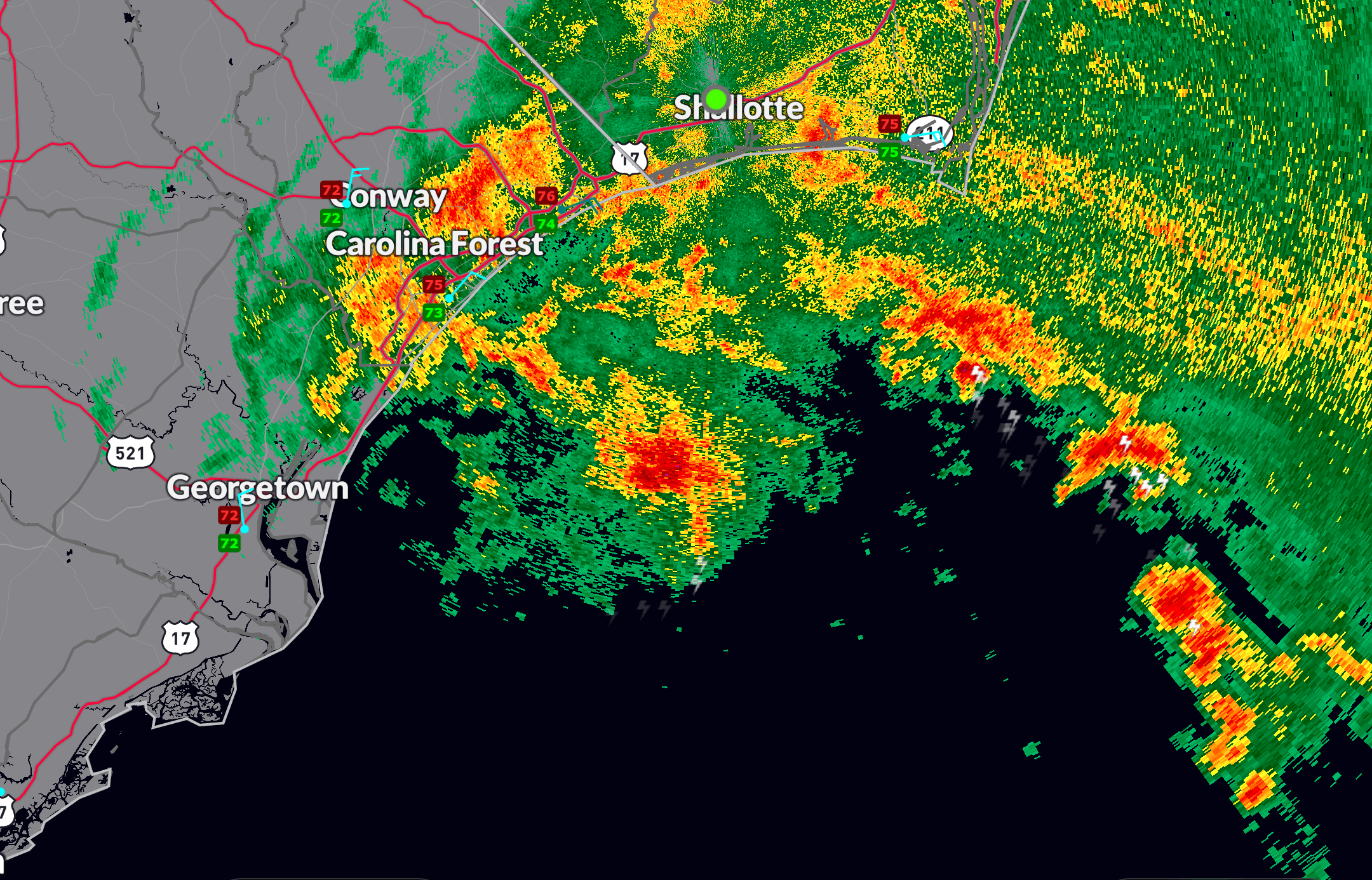
CHANTAL MOVES INLAND, STILL A THREAT TO THE CAROLINAS
Tropical Storm Chantal made landfall along the South Carolina coast early this morning and is now steadily weakening inland. As of Sunday morning, Chantal’s strongest winds and heaviest rains remain east of the center, lashing coastal North Carolina with squalls, gusts up to 50–60 mph, and rainfall totals of 3–6 inches. Flash flooding is the main concern today in eastern North Carolina and the southern Mid-Atlantic. The storm is expected to dissipate into a trough by Monday over central North Carolina. Dangerous rip currents continue along the East Coast from Florida to the Mid-Atlantic.
BEAUTIFUL BEACHES FORECAST: ALABAMA AND NORTHWEST FLORIDA
If you’re headed to the Gulf Coast, it’s a good-looking Sunday. Sunny skies and highs in the lower 90s are expected along the Alabama and northwest Florida beaches. Water temperatures are in the lower 80s, and surf heights remain near 1 foot. Rip current risk is LOW from Gulf Shores to Pensacola and Moderate from Destin to Apalachicola—so please still exercise caution near jetties, piers, or during outgoing tides. A few scattered afternoon storms are possible, especially in the Florida Panhandle, but most beachgoers will enjoy a dry and sunny day. UV Index remains EXTREME, so reapply that sunscreen!
THIS WEEK ON WEATHERBRAINS
Don’t miss Episode 1008 of WeatherBrains, broadcasting live Monday at 7 PM CDT on YouTube.com/WeatherBrains. This week’s guest is Melissa Marcelloni, meteorologist with the National Weather Service in Brownsville, Texas. Melissa brings a fascinating blend of experience—from working large-loss insurance claims across the country to forecasting hurricanes and microbursts in the Rio Grande Valley. She’ll share stories from storm chasing, her role in the 2025 National Storm Chaser Summit, and the human side of disasters like the Lahaina wildfires. Catch it live or download it anytime from WeatherBrains.com or your favorite podcast platform.
ON THIS DATE IN WEATHER HISTORY
In 1977, Birmingham was experiencing a brief but sizzling heat wave. On this date, the high temperature hit 102°F, the warmest reading in the Magic City since 1954.
Category: Alabama's Weather, ALL POSTS, Social Media, Tropical
About the Author (Author Profile)
Bill Murray is the President of The Weather Factory. He is the site's official weather historian and a weekend forecaster. He also anchors the site's severe weather coverage. Bill Murray is the proud holder of National Weather Association Digital Seal #0001 @wxhistorianSubscribe
If you enjoyed this article, subscribe to receive more just like it.


