Thunderstorms Bubble as Heat Cranks Higher
HOTTER SUNDAY WITH SCATTERED STORMS AHEAD
The summer heat is intensifying across Alabama today as high pressure continues to dominate. Temperatures as of midday range from 87°F in Anniston and Hamilton to 94°F in Andalusia—running a few degrees hotter than this time yesterday. Dewpoints are oppressive, hovering in the low to mid 70s statewide, with Selma and Gulf Shores both at 77°F. Heat index values are generally between 95–100°F, but are already as high as 106°F at Selma and Gulf Shores. If you’re outdoors, remember to hydrate frequently, take breaks in shaded or air-conditioned spaces, and never leave children or pets unattended in vehicles.
SCATTERED STORMS THIS AFTERNOON AND MONDAY
We’ll see scattered, mainly afternoon thunderstorms today and again on Monday, thanks to daytime heating and ample instability. The greatest risk for storm development lies over west-central and southern Alabama, where CAPE values are highest. Coverage should remain limited to about 20%, but any storm that forms could produce gusty winds, localized downpours, and dangerous lightning. Most storms will remain below severe limits, but a rogue severe storm can’t be ruled out. If you hear thunder or see a storm developing nearby, move inside immediately.
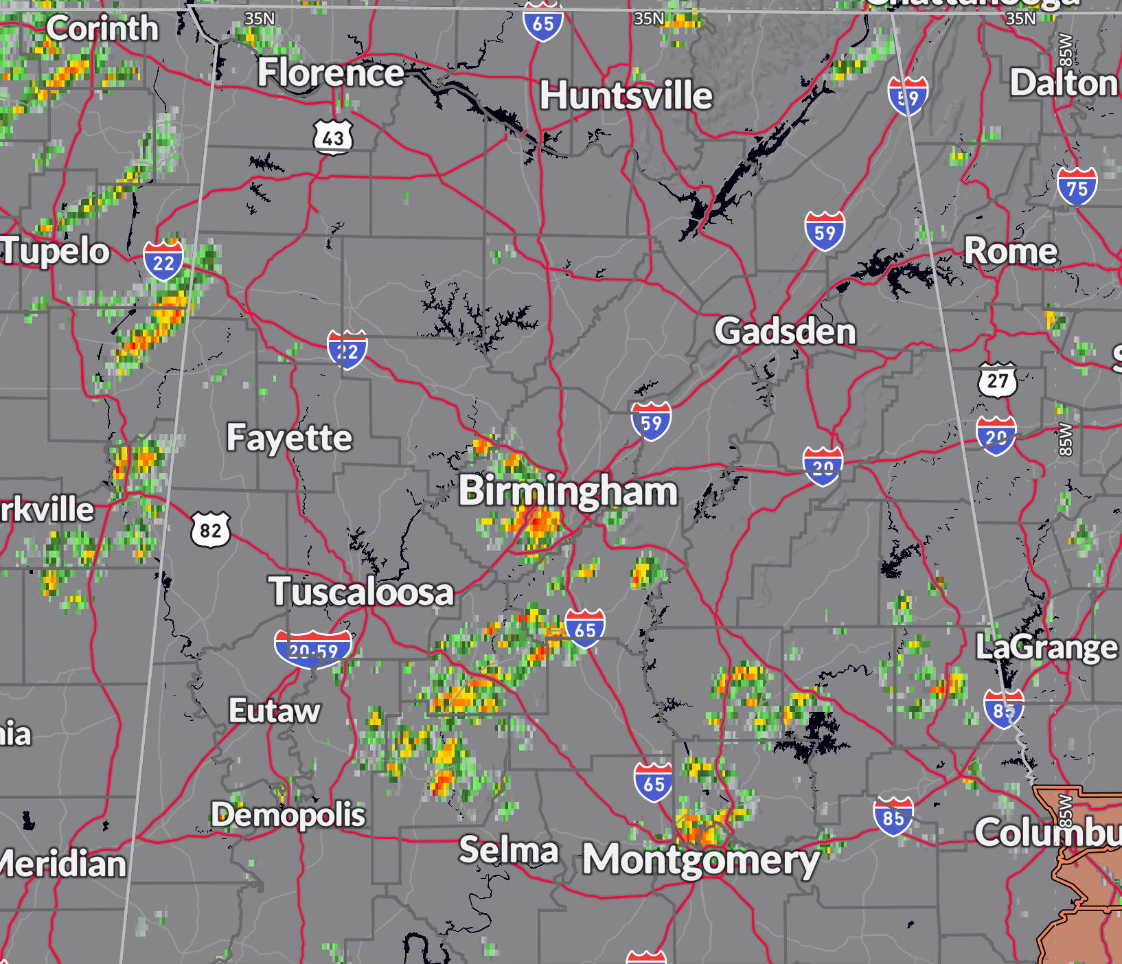
RADAR UPDATE AT 1:15 PM
Strong storms are moving across parts of Central Alabama at this hour including the Birmingham and Montgomery metros. Be ready for heavy rain, gusty winds, and dangerous lightning as they approach. Be inside a structure or automobile.
EXTENDED HEAT AND UV RISKS CONTINUE
Highs today will range from 90 to 96°F, with Monday likely a degree or two hotter. Heat index values will climb into the 100–108°F range across the state through midweek, especially west of I-65. That places most of Alabama in the moderate to major heat risk category through Saturday. The UV index remains in the extreme range—use sunscreen with SPF 30 or higher, wear light-colored clothing, and stay out of the direct sun as much as possible during peak hours.
TROPICS BEING WATCHED CLOSELY
A weak trough of low pressure is moving west-southwest across the western Atlantic and is expected to enter the Gulf this week. While conditions are marginally favorable, development is not likely. The National Hurricane Center gives it a low 20% chance of becoming a tropical cyclone. Regardless of development, it should bring increased rain chances to parts of southeastern Louisiana, Mississippi, Alabama, and the Florida Panhandle later this week. It won’t be a beach washout, but there will be scattered storms and increased clouds along the coast by midweek.
LOOKING AHEAD: TUESDAY THROUGH SATURDAY
Tuesday will bring more isolated to scattered storms with heat index values potentially reaching 105°F or higher, especially across central and west Alabama. On Wednesday, a shift in the upper-level pattern begins, as a low near Florida helps turn our winds more easterly. That will pull deeper moisture into the state, leading to more widespread rain and thunderstorm coverage by Wednesday afternoon. Storms will remain in the forecast through Friday, keeping highs down a few degrees—generally in the mid 90s with heat index values near 100°F. Next weekend may trend slightly drier again, but some scattered storms will still be possible.
ALABAMA WEATHER HISTORY
ON THIS DATE IN 1961…a woman was killed by lightning while sitting along the bank of Geneva County Lake near Coffee Springs, AL. A reminder that lightning often strikes well ahead of the main rain shaft—if you can hear thunder, you’re already in danger. Don’t wait. Get inside.
Category: Alabama's Weather, ALL POSTS, Social Media
About the Author (Author Profile)
Bill Murray is the President of The Weather Factory. He is the site's official weather historian and a weekend forecaster. He also anchors the site's severe weather coverage. Bill Murray is the proud holder of National Weather Association Digital Seal #0001 @wxhistorianSubscribe
If you enjoyed this article, subscribe to receive more just like it.


