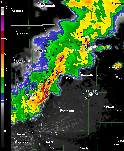
Thunderstorms Over Northwest Alabama
An upper trough is moving eastward across northern Mississippi and western Tennessee late this morning.
It is producing a line of showers and storms that extends from west of Lawrenceburg, TN to west of Florence, AL to near Fulton, MS, curving back to south of Oxford, MS.
Some of the strongest storms are over western Franklin County and about to enter western Marion County in Northwest Alabama. Lots of lightning with these storms.
They will also have the potential to produce strong winds.
The SPC has about the northern half of Alabama in their standard slight risk outlook for severe weather today. There is a 15% chance that you will have a severe wind event (58 mph or greater) within 25 miles of your location is you are in the risk area. Strong upper level winds are contributing to this threat. In fact, the segment approaching NW Marion County around Shottsville looks like it is bowing, indicating higher potential for damaging winds.
No watches or warnings in effect right now in Alabama, but I wouldn’t be surprised to see some.
There is about a 5% chance of a severe hail report within that 25 mile radius as well that covers much of Central Alabama.
Surface based CAPE values over the west part of Central Alabama are generally around 2000 j/kg, but a little less than that over the east. That is mainly because the air is drier over the eastern half of the state. There is a pocket of CAPEs above 2500 j/kg just ahead of the line over Northwest Alabama, so they probably will intensify over the next couple of hours, and then just hold their own as they steam eastward this afternoon.
Other storms were over Limestone and Jackson counties in North Alabama, with showers developing down through Cullman County. More storms will likely develop ahead of the main line over the next couple of hours with the strong heating that is going on.
The activity i moving more east than southeast for now, and this may keep it north of the Birmingham Metro area. We will be monitoring.
Category: Uncategorized


