Heat, thunderstorms update – 1219 pm
Temperatures have reached the lower to mid 90s, and with high humidity, the NWS has issued a heat advisory for most of Alabama (except the NE corner). The heat index is 102 at BHM, and above 105 in parts of Alabama. It may reach 110 later.
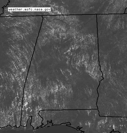
With the heat and humidity, the air is becoming unstable. You can see the cumulus clouds forming on satellite. With atmospheric precipitable water over 2 inches and CAPE near 3000 J/kg, some of the clouds will develop into strong thunderstorms this afternoon, with heavy rain and lightning. They will be scattered, and the highest concentration will likely be north-south along I-65 (Cullman, BHM, MGM) since that is where the boundary from yesterday’s rain is located.
The heat wave is still coming this weekend and early next week. Atmospheric moisture should decrease this weekend, keeping any clouds and thunderstorms to a minimum. Since we have had recent rain and the ground is not dry, this heat wave will not be like 2007, when temperatures were above 105. Some of the sun’s energy will go into evaporating moisture from the soil, so temperatures will get a little hotter each day, with some locations reaching 100 degrees. However, with the moisture, it will feel as hot as 2007, with heat index above 100 for several hours each day, and reaching 110 in the afternoons in many areas.
Even though temperatures may not get to historic heat wave levels, the humidity will make this a dangerous heat wave. Drink plenty of water, even if you’re not thirsty. Dehydration can hit you quickly and make you sick. Try to do any outdoor work, football practice, band practice, etc. before 10 am or after 7 pm. If you have to be outside during the day, take frequent breaks to air conditioning.
Category: Uncategorized


