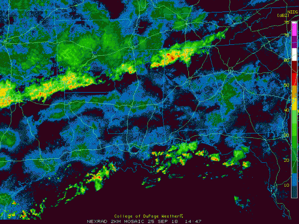
Showers and Storms
Showers and thunderstorms continue along a stalled frontal boundary from Central Tennessee through the Northwest corner of Alabama into Mississippi, Louisiana and back to Texas.
In Alabama, moderate to heavy rain is falling across much of Colbert, Franklin, Lawrence, Limestone and northwestern Morgan Counties. Radar estimates indicate that 1.5 to nearly 3 inches of rain have fallen across parts of this area so far this morning. Heavy rain was falling at this hour at the airport in the Shoals.
There is some thunder mixed in…especially over southwestern Franklin county, edging down into northwestern Marion County at this hour.
The activity is inching southeastward, with all of the individual cells moving to the east northeast along the boundary. Rain chances will be high through the day over the Tennessee Valley and Northwest Alabama. Scattered thunderstorms will develop across the rest of the area later today and continue into tonight. More rain is likely on Sunday as a stronger upper trough moves in from the northwest and a surface low develops over Alabama and Mississippi.
TEXAS FLOODS
Numerous flash flood warnings in the Dallas/Fort Worth area this morning. 1.99 inches of rain at Love Field in Dallas and 2.14 inches at the Fox Studios in downtown. One inch of rain in 20 minutes at the Arlington Airport. The heaviest rain has diminished in the Dallas area now but still continues in Fort Worth.
FOOTBALL
About a 1 in 5 chance of a shower or storm at the beginning of the Auburn game, increasing to about a 30-40% chance by the end of the game. Keep the rain gear with you and make a pre-game determination of radar trends before you head into the stadium. We will have updates throughout the day Tiger fans.
TROPICS
Lisa is back down to being a tropical storm this morning over the eastern Atlantic. SHe should be history by Tuesday as she meanders northward.
Matthew is deep into Central America now and will spend the next five days over land, causing tremendous flash flooding in that region. It will approach the southwestern Gulf by Tuesday but will barely be a remnant low then. It probably will not regenerate.
Another tropical system will likely emerge over the western Caribbean later this week and threaten Cuba and the Florida Keys by late in the week. It could could be a large and powerful storm.
Category: Uncategorized


