Quick Look Ahead
Much of northeastern Alabama is covered with a dusting of snow this morning. We have had reports of powdery snow covering parts of Cullman, Etowah, and Cherokee Counties. Some roads are covered with powder, but there has not been much ice other than in DeKalb and Jackson Counties where some roads are impassable. You can follow ALDOT’s road closure situation here: ALDOT.
The cold wind is going to be the biggest issue this afternoon. Afternoon highs will only reach the 20s and 30s with a gusty northwest wind at 10 to 20 miles per hour. That will drive the wind chill down into the 10s and 20s for most of the day.
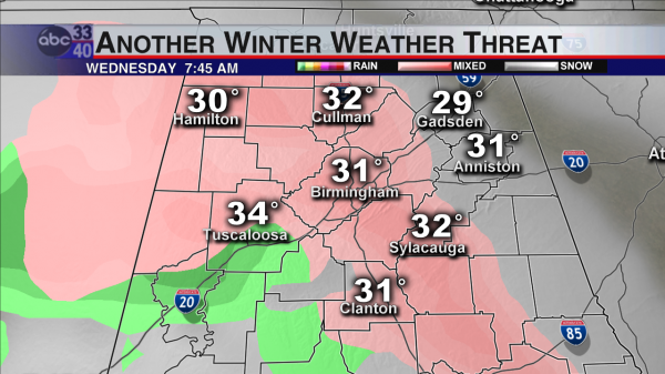
Arctic air like this is hard to move, and as warmer air tries to replace it on Wednesday, there is a chance we may have to deal with some wintry issues Wednesday morning IF the precipitation gets here in time. Very light freezing drizzle or freezing rain could cause some issues Wednesday morning. Here is the latest RPM (rapid precision mesoscale…it’s the model run by WSI Inc. out of Andover, MA) model look for Wednesday morning:
This is a model, and just like any other model, it is not a perfect representation of the future weather. It is a guide to help us make a more accurate weather forecast. That being said, the RPM is a little faster with getting precipitation in here than any of the other US or foreign models. This model usually does a very good job with light precipitation and timing, so I would expect that someone will have a little ice on Wednesday morning.
Who gets it and how much? James outlined an area north of a line from Millport to Brent to Roanoke in the Weather Xtreme Video this morning. That is most likely where the temperature will be below freezing at the onset of precipitation, and that looks like a very good estimate on Monday morning. Since the precipitation will be very light, ice accumulations would generally be under 1/10 of an inch (definitely not a crippling storm). This idea will be studied and refined in the next 36 hours, so the forecast has some room for change in it. Any changes will likely be toward no ice instead of a major winter storm.
Category: Alabama's Weather, Winter Weather


