What is an “upper-level disturbance” anyway?
First of all, the consensus of the models indicates that the main southern stream disturbance we’ve been talking about is going to be too far south for any significant snow on Christmas in north and central Alabama. Maybe a little light snow SE Alabama, but that’s about it on that one. See my earlier post on just how complicated models are, and why big differences can arise.
However, as a secondary shot of cold air comes in from the north late on Christmas Day into that night (highs Sunday and Monday only in the mid 30s), an upper-level disturbance will move down from the north, and this one may produce enough lift for some light snow late Christmas Day into Saturday night. Also, with the Arctic air coming in, we could see a few convective snow showers (like summer thunderstorms), since the air aloft will be so cold. Overall, unless the European model is right about a lot of moisture surging in here (probably not), we’re looking at a dusting in most places, with maybe 1″ in a few isolated spots that get a heavier snow shower at a higher elevation.
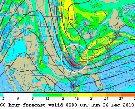
What is an “upper level disturbance”, and how do they cause precipitation? You also hear us call them “vorticity maxima”, “vort max”, “shortwaves”, and “upper level energy”. In the map at the top of this blog, you can see the vorticity, or spin in the atmosphere, shaded in color, and see the maximum coming through Mississippi and Arkansas. Notice how the vorticity maximum, or “upper level disturbance”, is located in the area where the solid lines (500 mb heights…the wind generally flows along these), are curved the most.
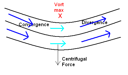
The above diagram shows the classic features of an upper disturbance, or vort max, causing divergence (and upward motion, see below). The air generally moves parallel to the height lines (the dark blue wind arrows). But, in the curved trough, there is centrifugal force trying to throw the air out of the flow, southward. The atmosphere trys to stay in balance, so through a combo of the pressure gradient, Coriolis force, and centrifugal force, the air in the curved part of the trough is slowed down (light blue wind arrow) so that it can stay in the balanced flow. This causes convergence at upper levels to the west, or upstream, of a vort max.
As it comes out of the curved region, the centrifugal force goes away, and a combo of the Coriolis and pressure gradient speed it back up to keep it in balanced flow again. In going from slower wind speeds in the trough to faster wind speeds downstream, this creates upper level divergence.
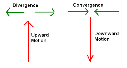
As the above chart shows, when there is upper level divergence (such as just downstream of the upper disturbance), air has to come in from somwhere to fill in the empty space left by the air. It’s too stable for it come from higher, so it comes from below, causing upward motion, and sometimes precipitation. Behind the trough where you have upper convergence, the air is pushed downward, drying things out. So, once the vort max is by you, the weather usually improves.
Not all vort maxes are this simple. Jet streams get involved, and that is something we can talk about another day.
Merry Christmas!
Category: Met 101/Weather History, Winter Weather


Comments (36)
Trackback URL | Comments RSS Feed
Sites That Link to this Post