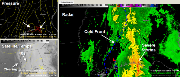
Heaviest Rain Moves East
Our cold front extends from Anniston to Clanton to Linden at this hour.
The heaviest rain extends from rainbow City to Ohatchee and Ragland to Pell city, Harpersville, and Clanton. The overall intensity of the precipitation has decreased a bit in the past hour.
1.80 inches at the Birmingham Airport from yesterday through 9 p.m. tonight. We might see another tenth of an inch before the rain ends here.
40s are already moving into Northwest Alabama. It’s already 46F at the Shoals and 45F at Haleyville.
The clearing line is approaching the Mississippi River. It should reach West Alabama around 2 a.m. and the I-65 corridor about 4 a.m. Drier air filtering in with the cooler air should keep widespread fog from forming, but there could be a little patchy dense fog as the quick clearing happens later.
Sunday will feature increasing sunshine with a breezy north wind. Afternoon temperatures will be limited to the 50s.
We will likely see a light freeze across much of the area Sunday night.
Expect dry conditions Monday and Tuesday with highs in the 60s.
The next rain chance will come after midnight Tuesday night/Wednesday morning. Now it appears that instabilities will be in the 250-750 j/kg range early Wednesday morning. This will be enough to produce some severe weather. If this system runs a little late, it could push the peak chances into Wednesday afternoon which would mean better instability and the chance of some strong to severe storms.
It will be blustery and colder Thursday with highs in the 50s. We will be back close to freezing Friday morning before returning to highs in the 60s Friday through Sunday. We could be back near 70F by Sunday as the southerly flow increases ahead of our next storm system, which is expected in here Monday and Monday night.
Both systems should produce about an inch of rain apiece.
Category: Alabama's Weather


