Update on flooding and rain
At 1157 am, radar (to the right and down a little) shows that the rain has mainly ended W of a line from Piedmont to Sylacauga to Prattville to Selma, with severe storms and tornadoes reported this morning in south Alabama (see posts below for details).
However, this was a big rain event, especially after the 2-3″ rain we received this weekend. Some rainfall reports (some of these were at 830 am, and more rain has fallen since then: BHM 3.3″, TCL 3.8″, Cullman 4.0″, Trussville 3.7″, Helena 3.2″, GAD 2.9″, ANB 3.9″, HSV 2.8″.
That rain is running into creeks and rivers today, creating some flooding problems. Several roads were reported under water earlier this morning, and this may continue this afternoon. Turn around, don’t drown! Many fatalities each year in the U.S. occur because people try to drive across a water-covered roadway, probably underestimating the depth.
As far as the rivers go, flood warnings are in effect along parts of the Cahaba and Warrior River systems.

The Cahaba River at Cahaba Heights rose to 11 ft. this weekend, and is approaching 12 ft. and rising quickly today as water from eastern Jefferson county flows into it. It is expected to crest near 18′ late tonight or tomorrow morning, causing some minor flooding in commercial areas.
The Mulberry Fork of the Black Warrior River at Cordova went above flood stage this morning, and continues to rise rapidly as water from Blount, Cullman, Walker, and Winston counties flows into it. This is the highest this river has been since it reached 24′ in the big flood of January 2009.

The Locust Fork of the Warrior River is also rising quickly, but is still below flood stage of 25′. The river should go above flood stage tomorrow as rain from Jefferson and Blount Counties makes it way through streams and creeks to the river. Minor flooding of low-lying areas along the river is expected.
We’ll also have to keep an eye on the main Warrior River (Bankhead Lake, Holt Lake, and Oliver Lake in Tuscaloosa). In January 2009, when the water reached 24′ at Cordova, homes were flooded in locations like Copeland’s Ferry, and a significant flood affected Bankhead Lake.
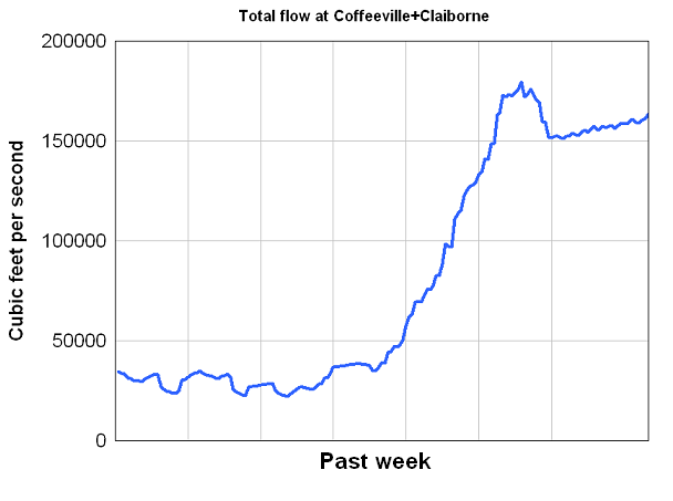
A good way to measure the overall water flow out of Alabama and into Mobile Bay is to look at the streamflow at Coffeeville on the Tombigbee River plus the streamflow at Claiborne Dam on the Alabama River. All water that flows through the Tombigbee, Warrior, Cahaba, Alabama, Coosa, and Tallapoosa Rivers flows past these points (i.e., most of Alabama south of the Tennessee River Valley.)

So, 160,000 cubic feet per second, or 1 million gallons per second, are flowing past these points already, and a lot of the rain that fell last night has not made it that far downstream yet.
Category: Alabama's Weather
About the Author (Author Profile)
Subscribe
If you enjoyed this article, subscribe to receive more just like it.


