Good Looking Saturday
A beautiful Saturday is in progress across Alabama with a good supply of sunshine, a few clouds and some warm temperatures.
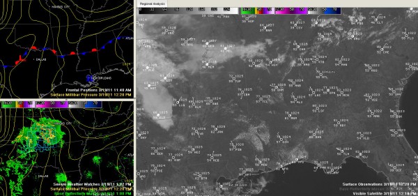
A cold front has progressed down into Central Alabama, but it is accompanied by really nothing in the way of sensible weather except for a wind shift to the north and northwest. There are no clouds along the front, and the clouds that were with it in Tennessee have eroded rapidly late this morning.
The mercury was held back a bit over the Tennessee Valley thanks to those clouds, with Muscle Shoals checking in at 66F at noon. But they will be catching up pretty quickly to the rest of us and our 70 degree readings this afternoon.
It was 77F at Tuscaloosa and Birmingham and 78F at Anniston at noon.
Radars are quiet and pretty much expected to stay that way for the rest of the day. There could be an isolated shower or two, but the chances look pretty small.
Tomorrow should look a lot like today for areas west of I-65. Eastern sections could deal with an easterly wedge setup as high pressure near Chicago moves southeastward to along the Mid-Atlantic coast tomorrow. The flow around this high will be blocked by the Appalachians and will be forced southward into Georgia and eastern Alabama. This easterly flow will be accompanied by more clouds and cooler temperatures.
Look at these expected high temperature profiles for tomorrow:
Hamilton 80F, Gadsden 72F.
Vernon 82F, Birmingham 77F, Anniston 72F.
There could also be a few showers tomorrow as this cooler air acts as its own little cool front edging westward into the state from the east.
For tonight, skies should be partly cloudy with temperatures dropping into the 60s by 8:30 or so.
Be on the lookout for the gorgeous supermoon, which should rise at 7:15 p.m. CDT (Birmingham). It will be closer and brighter than any moon since March 1993. About 14% larger and 30% brighter. Hopefully the sky will cooperate, and it looks like it will.
On the lower left panel of the graphic, you can see lots of storms over the Central Plains. A severe thunderstorm watch is in effect for southwestern Missouri, southeastern Kansas and northern Oklahoma. So far, there have been nearly 20 severe hail reports. Two inch hail was reported near Coffeyville KS around 8:30 this morning. Do you know what Coffeyville is famous for in meteorological circles?
Category: Alabama's Weather


