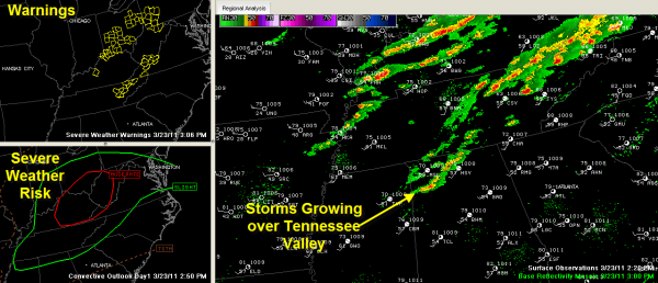
Showers Growing over North Alabama
It is a warm, windy spring day across Alabama. Temperatures are mostly in the 70s. Tuscaloosa reached 81.
Showers have developed over North Alabama’s Lawrence, Limestone and Madison Counties. They are slowly intensifying and will become storms soon as they move quickly eastward.
These storms may become severe over the next few hours from the Shoals area over to Scottsboro.
The SPC expanded the risk area for severe weather ever so slightly to the west to include all of Alabama’s Tennessee Valley Counties, even into Northeast Mississippi.
We still have the moderate risk area over Kentucky, Ohio, West Virginia and extreme southwestern Virginia. A tornado watch covers much of this area.
Numerous severe thunderstorm warnings are in effect over Northeast Tennessee, eastern Kentucky, Ohio, southwestern Pennsylvania and southern West Virginia. There have been several large hail reports from that region along with a couple of high wind reports.
Additional showers and storms will develop further south later this afternoon and evening, as far south as the I-20 corridor. An isolated storm could be on the strong side, but significant severe weather is not expected.
Category: Alabama's Weather


