An Ominous Note
Tomorrow is the 17th anniversary of the Palm Sunday Tornado Outbreak. What began as a peaceful Palm Sunday quickly changed to a black day in Alabama weather history on this date when a powerful tornado ripped through northeast Alabama.
By the time the storm was over 22 were dead and 92 were injured by the twister. The F4 tornado cut a 50 mile path from Ragland in St. Clair, County Alabama to the Georgia line.
The storm touched down near Ragland at 10:51 am. The storm struck Ohatchee, then roared across northeastern Calhoun County, passing near Piedmont and hitting Goshen, where it struck the Goshen United Methodist Church at 11:37 am.
Twenty people were killed at the church, which did not hear the tornado warning issued ten minutes earlier by the National Weather Service in Birmingham.
Having said that…John DeBlock at the National Weather Service in Birmingham noted the following in our media chat…
Hey folks…didn’t want to sound too alarmist in the AFD…but in discussion with SPC…we both were reminiscing the March 94 set up as being very similar to this. Lack of a clear trigger…strong QS boundary with cells riding over it…those of you familiar with the meteorology will recognize it. We will have to watch any cells riding along such a boundary very closely. Media types…i know you’re getting the info out in your blogs/feeds…just want to encourage people to stay close to home once the watch and action gets going. We’re quiet for the moment…but things will get busy in a hurry most likely.
As John said, we don’t want to alarm anyone, but there is lots of activity going on across Central Alabama this afternoon and we just want people to keep an weather eye out and pay attention to watches and warnings.
Remember, a tornado watch is issued when conditions are favorable. That is a certainty by early afternoon. A tornado warning is issued when radar shows indications that a tornado is occurring or may be about to form, or reports indicate that one is on the ground.
Pick out your reliable source of severe weather information and keep it with you throughout the day and night…
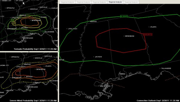
Here is the new convective outlook from the SPC…
The new SPC convective outlook has just been issued…
ACUS01 KWNS 261614
SWODY1
SPC AC 261612
DAY 1 CONVECTIVE OUTLOOK
NWS STORM PREDICTION CENTER NORMAN OK
1112 AM CDT SAT MAR 26 2011
VALID 261630Z – 271200Z
…THERE IS A MDT RISK OF SVR TSTMS PARTS OF CENTRAL AND NORTH AL
AND NORTHEAST MS…
…THERE IS A SLGT RISK OF SVR TSTMS FROM PARTS OF THE LWR MS VLY
EWD INTO AL/GA/SC…
…SYNOPSIS…
S/WV TROUGH CENTRAL PLAINS EMBEDDED IN FAST ZONAL FLOW WILL CONTINUE
EAST ACROSS MS INTO TN VALLEY BY THIS EVENING. FROM THE SURFACE LOW
OVER SERN OK A NEARLY STATIONARY FRONTAL ZONE EXTENDS EWD ACROSS
SRN AR AND NRN GULF STATES JUST TO N OF BHM TO NEAR ATL. COLD FRONT
TRAILS SWWD FROM SURFACE LOW ACROSS NWRN INTO SWRN TX.
THE WARM SECTOR OVER CENTRAL GULF STATES FROM ERN TX TO AL AND
SPREADING EWD INTO SRN GA S OF FRONTAL ZONE IS BECOMING VERY
FAVORABLE FOR DEVELOPMENT OF SEVERE THUNDERSTORMS INCLUDING
SUPERCELLS THIS AFTERNOON.
IN ADDITION TO THE E/W FRONTAL ZONE ACROSS NRN GULF STATES PROVIDING
A FOCUS FOR SURFACE BASED CONVECTIVE INITIATION THE WARM SECTOR
ACROSS CENTRAL AL/MS THROUGH HEATING WILL LEAD TO POTENTIAL OF
DISCRETE SEVERE THUNDERSTORMS AS CINH DISSIPATES BY MID AFTERNOON.
STEEP MID LVL LAPSE RATES AND RELATIVELY COOL PROFILES WILL SUPPORT
MDT INSTABILITY WITH MLCAPES AOA 2000 J/KG FROM LWR MS VLY TO
CENTRAL AL THIS AFTERNOON.
…PARTS OF CENTRAL/NRN AL INTO NRN MS…
WITH 30-40KT LOW LEVEL WSWLY FLOW VEERING SHEAR PROFILES WILL BE
QUITE FAVORABLE FOR SUPERCELLS INCLUDING TORNADOS AND VERY LARGE
HAIL. IT NOW APPEARS THAT SURFACE BASED INITIATION WILL BE ABLE TO
OCCUR BY MID AFTERNOON IN THE WARM SECTOR WHICH INCREASES THE THREAT
OF LONG-LIVED SUPERCELLS AND ASSOCIATED TORNADOES. THE AREA OF
GREATEST RISK OF THIS OCCURRENCE HAS BEEN UPGRADED TO A MDT
RISK…ALTHOUGH THE GREATER POTENTIAL COULD EXTEND EVEN INTO WRN GA
IF SUFFICIENT INSTABILITY DEVELOPS . THERE IS THE THREAT OF STRONG
TORNADOES WITH ANY SUSTAINED SUPERCELLS.
…SRN/ERN AR/NRN LA EWD ACROSS AL/GA AND SC…
FURTHER W THE INITIALLY STRONGER CAP THROUGH THE PROCESS OF HEATING
AND ASCENT ALONG THE COLD FRONT WILL WEAKEN BY LATER THIS AFTERNOON
TO ALLOW SEVERE THUNDERSTORM DEVELOPMENT FROM SRN AR INTO NRN LA.
WHILE LOW LEVEL SHEAR WILL NOT BE QUITE AS FAVORABLE AS FURTHER
E…MLCAPES IN EXCESS OF 2000 J/KG…BRN SHEAR OF 40-50KT ALONG WITH
THE VERY STEEP MID LEVEL LAPSE RATES WILL ALSO SUPPORT SUPERCELLS.
IN ADDITION TO THE VERY LARGE HAIL THREAT…A FEW TORNADOES ARE ALSO
LIKELY.
OVERNIGHT THE STORMS THAT DEVELOP OVER AL/MS THIS AFTERNOON WILL
HAVE SPREAD EWD ACROSS GA WITH AT LEAST A THREAT OF LARGE HAIL AND
DAMAGING WINDS IN PARTS OF WRN SC WHERE AIR MASS WILL BE MORE
MARGINALLY UNSTABLE. MEANWHILE THE COLD FRONTAL INITIATED ACTIVITY
WILL MAINTAIN A SEVERE THREAT INCLUDING SUPERCELLS AND ISOLATED
TORNADOES EWD ACROSS CENTRAL MS/AL AND POSSIBLY INTO SRN GA BY
EARLY SUN.
..HALES/ROGERS.. 03/26/2011
Category: Alabama's Weather, Severe Weather


