Alabama Weather Update at 10:45 a.m.
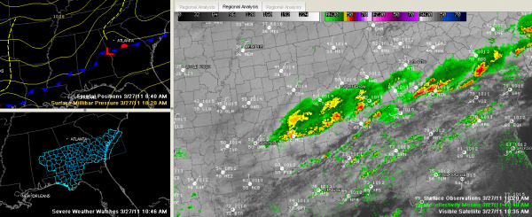
This graphic tells thie Alabama weather story best right now…
Showers and thunderstorms continue this morning across the southern half of Central Alabama, mainly south of a line from Aliceville to Coaling to Columbiana to Ashland and Wedowee.
There was a severe thunderstorm warning for Chilton, Elmore and Coosa Counties but it was allowed to expired and not extended eastward as the storms weakened. There was quarter sized hail with this storm in Chilton County. This activity will reach Dadeville around 11:15 and should stay just south of Alex City.
The boundary has pushed south to a line from Butler to Camden to Montgomery to Opelika. It should sink a little further south this afternoon, helping to push the storms a little further south.
Storms were beginning to form over South Alabama, where a severe thunderstorm watch is in effect until 4 p.m. The watch comes as far north as Perry, Chilton, Coosa, Tallapoosa and Chambers Counties.
Clouds and cool conditions will prevail from I-20 north this afternoon with temperatures in the 40s and 50s. The high will go in the books as 63F at Birmingham today, but that occurred just after midnight. I will use that as the afternoon high in the forecast, and folks from Dempolis to Maplesville to Alex City will see early afternoon temps in the lower 60s…but everyone else north of that will be cooler.
Category: Alabama's Weather, Severe Weather


