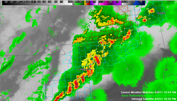
Late Evening Look at the Severe Weather Threat for Monday
SEVERE WEATHER LIKELY MONDAY: Unfortunately, we will be dealing with a fairly significant severe weather threat across Alabama on Monday. Low pressure is over eastern Iowa tonight, with a cold front trailing back into Oklahoma Panhandle. A warm and increasingly moist airmass is overspreading the Mississippi Valley and and Southeast, with 65F dewpoints into Iowa.
Low clouds will develop by morning across much of Central Alabama thanks to the influx of moisture from the Gulf.
Winds will continue to blow at 10-15 mph overnight and will increase to 15-25 mph with 35 mph gusts on Monday.
Those low clouds will break up later Monday morning, allowing for a decent supply of sunshine which will quickly allow temperatures to warm into the upper 70s to lower 80s. The airmass will become moderately unstable, with CAPEs reaching 1500-2000 joules/kg2 by lunchtime. Lifted indices will be -5 to -8 across the western half of Central Alabama by noon. This is sufficient for strong thunderstorm updrafts to develop.
One thing in our favor is that a strong capping inversion is expected to be in place across the state, with temperatures rising instead of falling with height for some distance above the surface. This will suppress thunderstorm development for much of the day over Alabama.
Severe thunderstorms developed this evening from eastern Oklahoma into Michigan. Tornado and severe thunderstorm watches are in effect late tonight. Those storms will move northeast toward the Ohio Valley this morning. Thunderstorms will fire southward ahead of a cold front as it approaches the Mississippi River early this afternoon, like a string of firecrackers.
Those storms will likely become severe by mid-afternoon over Central Mississippi. They will be approaching the northwest corner of Alabama by 5 p.m. or so. The line will move rapidly eastward at 45 mph, reaching a line from Lamar through Walker Counties by 6 p.m. and I-59 about an hour later. They will reach extreme eastern Alabama by 9:30 p.m. This timing could change and is just for general planning purposes.
THE THREATS: The biggest threat from this system will be from damaging thunderstorm winds from the cells along the line. But there will be sufficient low level shear to potentially spin up isolated tornadoes in any discrete segments that separate themselves. A bigger tornado concern will develop if any isolated thunderstorms develop at the last minute ahead of the main line, especially over West Central Alabama.
ALL INTERESTS SHOULD MONITOR THE WEATHER THROUGH MONDAY NIGHT: Needless to say, everyone should pay close attention to this developing weather situation.. Look for tornado watches by mid to late afternoon and a slew of thunderstorm and tornado warnings late Monday afternoon into Monday evening. Now is the time to review your personal tornado safety plan and make sure that you will have access to warnings when they are issued. We will be monitoring the situation carefully throughout the day and tonight.
Category: Alabama's Weather, Severe Weather


