Upper Midwest Severe Weather Outbreak Beginning
Interestingly enough, tomorrow is the 46th anniversary of one of the most disastrous tornado outbreaks in U.S. history. The Palm Sunday Outbreak killed 256 people across the Midwest. While Illinois, Indiana, Michigan and Ohio were the hardest hit, Wisconsin did have three fatalities.
The Badger State is getting ready to experience another potential tornadic severe weather outbreak through the evening, with the potential for long lived, strong tornadoes.
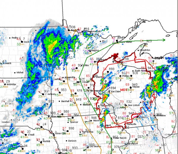
The SPC has issued a PDS tornado watch that goes until 11 p.m. CDT tonight for the area depicted in dark red on the map. The lighter red outlines the moderate risk outlook area.
The atmosphere across that region has become moderately unstable this afternoon beneath a strong capping inversion. The lid is about to come off the boiling pot with strong winds aloft getting ready to move over the region. If you look closely at the wind barbs and pressure readings on the map, you might can pick out the surface low near Grantsburg WI (northeast of Minneapolis). It continues to intensify, now with a minimum pressure of 990 millibars.
Storms are firing as you can see from the radar underlay and a few severe thunderstorm warnings are in effect.
Further south, storms will fire through the evening through the Midwest and into Arkansas and Northeast Texas. We will deal with this southern end of the activity ahead of a cold front tomorrow in Alabama. We don’t expect anything like they are going to experience in Wisconsin here, but we will deal with severe thunderstorms and the threat of damaging wind and hail tomorrow. There is a small threat of tornadoes as well.
Category: Alabama's Weather, Headlines, Severe Weather


