Situation Continues to Deteriorate
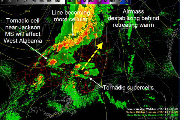
A tornado warning was just issued for the area around Columbus MS. The line of storms over eastern Mississippi and western Alabama is becoming more cellular as the airmass destabilizes to the south of it. These more individualized thunderstorms have a higher potential to produce severe weather.
These storms will affect northern Pickens, Lamar and Marion Counties over the next hour or two. Be alert for more warnings.
Here is the situation:
Tornadic supercell just east of Jackson will affect West Alabama’s Pickens/Sumter.Greene and perhaps Tuscaloosa Counties in about 2.5-3 hours. Tornado damage has been confirmed in the Jackson Metro area.
Supercells over Southwest Alabama pose a great threat to Central Alabama from Evergreen up through the Black Belt to between Montgomery and Birmingham. There are numerous reports of damage in Choctaw County from a tornado. Places from Shelby and Chilton County south and southwestward should be monitoring the weather very closely as we go through the next few hours.
Category: Alabama's Weather, Severe Weather


