Late Morning Look
I love a spring morning like today…clouds, a little sun, mild temperatures, a few showers around. What can we expect for the afternoon? Let’s see…
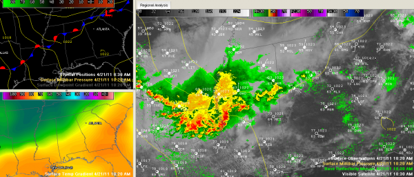
On the radar, there is a light shower over northwestern Jefferson County. Heavier showers are over Pickens County in West Alabama.
But the main action is over the Arklamiss…southeastern Arkansas, western Mississippi and northern Louisiana. This big complex of thunderstorms is pushing southeast.
This complex will dive southeastward across Mississippi. Its eastern fringes may brush West Central Alabama this afternoon. There are no severe weather watches or warnings right now. The SPC does have much of Central Mississippi outlooked in their standard slight risk category for today. That risk area does touch West Alabama’s Sumter County, but I doubt severe weather will be a probblem.
In keeping with this forecast idea, the NWS has dropped the flash flood watch for the area with the exception of Marion, Lamar, Fayette, Winston, Walker, Pickens and Tuscaloosa. The watch remains in effect until 7 p.m.
For the rest of Central Alabama, a few isolated showers and storms may break out during the day, but they are not expected to get out of hand. Highs should top out around 80F on average. Tomorrow should be drier and warmer with a high in the middle 80s, more sunshine, a breezy south wind and just a slight chance of an isolated shower or storm.
Category: Alabama's Weather


