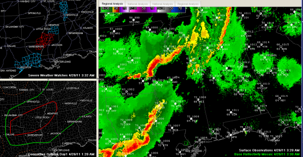
Round One Storms Weakening…More Action Later Today
The powerful line of thunderstorms that raced eastward out of Arkansas and Louisiana after causing big problems last night weakened as expected as it crossed northern Mississippi.
It is a shadow of its former self now.
At 3 a.m., no warnings or watches were in effect for Alabama. The NWS canceled the severe thunderstorm watch for the northwestern counties of the state and has been able to alert for the storms along the line, instead of using severe thunderstorm warnings. There were four reports of thunderstorm wind damage over Lauderdale County in Northwest Alabama.
The line extends now from just west of Athens to west of Moulton to near Hamilton in Marion County. It then extends to near West Point in eastern Mississippi.
I do note that the storms around Columbus MS have gotten a little stronger in the past few minutes despite the general weakening trend. These storms may tap slightly unstable air (500-1000 j/kg) over West Central Alabama over the next couple of hours as they move toward northern Lamar and Marion Counties, but the initial line has basically blown itself out now, with an outflow boundary puffing out of the line in the past few radar images. This will probably keep them from intensifying significantly.
But, this boundary may be a problem later today as it settles toward the I-59 corridor.
To the west, another wave of storms was stronger over eastern Arkansas and northwestern Mississippi. A tornado watch remains in effect for the Delta region of southeastern Arkansas, northeastern Louisiana and western Mississippi.
A tornado warning was just issued by the NWS Jackson for Bolivar County in the Delta.
Flash flood watches are up for much of Arkansas, western Tennessee and northern Mississippi, and will go into effect at 7 a.m. for parts of the Tennessee Valley of North Alabama.
I saw a five day precipitation forecast from the HPC last night with a bulls eye of 7-8 inches near Memphis.
The SPC has the northwestern half of Alabama, generally from Coffeeville to Clanton to Roanoke, under their standard slight risk outlook for today. A moderate risk is up for western Tennessee, much of Arkansas, southeastern Oklahoma and northeastern Texas and extreme northern Louisiana. The SPC wanrs that there could be a few strong to violent tornadoes later today across the moderate risk area from northeastern Texas through Arkansas.
Dr. Tim has a great post right under this one that discusses the potential for severe weather later today across Alabama.
Arkansas was hard hit last night, with numerous reports of wind damage and tornadoes. I just saw an AP report of two fatalities in Vilonia AR, north of Little Rock. In Hot Springs Village, several homes were damaged or destroyed by a possible tornado.
Category: Alabama's Weather, Severe Weather


