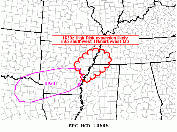
High Risk Will Be Expanded Into NW Mississippi/Western Tennessee
The SPC is concerned that the significant severe weather risk will expand into western Tennessee and Northwest Mississippi later today and tonight and will expand the High Risk outlook area at 11:30 when the updated Day One Convective Outlook is issued.
MESOSCALE DISCUSSION 0585
NWS STORM PREDICTION CENTER NORMAN OK
1051 AM CDT TUE APR 26 2011
AREAS AFFECTED…FAR EASTERN AR/SOUTHWEST TN/NORTHERN MS
CONCERNING…OUTLOOK UPGRADE
VALID 261551Z – 261645Z
THE EXISTING CATEGORICAL HIGH RISK WILL LIKELY BE EXPANDED
NORTHEASTWARD IN THE FORTHCOMING 1630Z DAY 1 OUTLOOK TO INCLUDE
REMAINING PORTIONS OF EASTERN AR…WHILE ADDING PARTS OF SOUTHWEST
TN/NORTHWEST MS INTO A HIGH RISK. FOR ADDITIONAL METEOROLOGICAL
DISCUSSION…SEE THE FORTHCOMING DAY 1 OUTLOOK THAT WILL BE ISSUED
BY AROUND 1630Z.
..GUYER.. 04/26/2011
Category: Severe Weather


