PDS Tornado Watch Coming Soon
The SPC says they will issued a Particularly Dangerous Situation Tornado watch for much of Alabama into Middle Tennessee/Northwest Georgia.
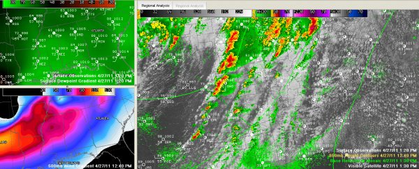
Instability levels are rising quickly over Alabama. Look at the dewpoint gradient over the Southeast in the upper left hand panel of the graphic.
Storms are beginning to fire quickly in Mississippi, including some monster storms over western Mississippi. There are three tornado warnings in North Central Mississippi now.
The storms on a line from Jackson to northwest of Starkville will develop into problems for us in the next couple of hours.
They will intensify rapidly under intense upper level winds. Look at the strong wind maxes pushing across Mississippi and Alabama. Those jet maxes act as if they are sucking on a straw, drawing these thunderstorm updrafts upward and stretching the spin in the atmosphere.
There is tremendous wind shear in the low levels of the atmosphere as well, which makes long tracked tornadoes possible.
For the people who don’t think the airmass has gotten unstable…here is date from the NWS from their noon balloon release:
18z flight data — SBCAPE 2722 j/kg; 0-3km SRH 842 m2/s2; BRN=13.5
That’s surface based CAPE of 2,722 j/kg, which is very unstable. The Storm Relative Helicity is off the scale. The Bulk Richardson Number is indicative of sustained supercells.
Category: Alabama's Weather, Severe Weather


