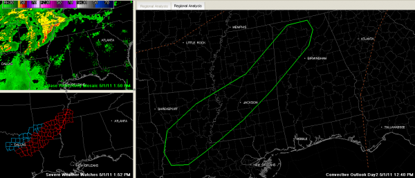
Severe Weather Possible on Monday
Nobody wants to hear this, but we are seeing signs that there will be some severe weather over West Central and Northwest Alabama Monday afternoon and evening…
SEVERE WEATHER TO OUR WEST…A tornado watch is posted this afternoon from northeastern Texas through Arkansas into the Memphis area. Severe thunderstorms are developing this afternoon in the unstable air ahead of a cold front that extends across Arkansas to a low over northeastern Texas. Supercell storms are likely and there will probably be a few tornadoes. This activity will stay well northwest of Alabama this afternoon and tonight.
ALABAMA SITUATION: Skies are partly sunny across Alabama, with the most sunshine over eastern sections. Temperatures were in the middle and upper 70s over western sections, and lower 80s already over eastern sections. There were a few very light showers showing up on radar over eastern Mississippi and western Alabama. There is a slight chance of a shower or storm over Northwest Alabama this afternoon and evening. Central Alabama should remain dry.
TOMORROW: Unstable air will be over Northwest Alabama by early afternoon. Scattered showers and storms will form over Mississippi during the day on Monday and move into Northwest Alabama. Strong deep layer shear will result in the potential for organized thunderstorms. It now appears that supercells could even be involved. The good news is that the shear profiles will be unidirectional (winds blowing out of same general direction as you go up in height) which means the primary threat will be damaging winds and hail and not tornadoes, but the possibility cannot be ruled out.
SPC ISSUES DAY TWO OUTLOOK FOR ALABAMA: The SPC has added a slight risk outlook for Northwest Alabama generally to the left of a line from Gainesville to Northport to Hayden to Guntersville to Gurley to Lexington to Red Bay. This is not a forecast, but an outlook, or guidance. It is their standard outlook to alert us to the possibility of severe weather.
NOT GOOD NEWS: Everyone is understandably nervous about severe weather right now. But please know this is nothing like last Wednesday’s event, which we hopefully will never see again in our lifetimes. Still, everyone over Northwest Alabama should be alert for the possibility of severe weather on Monday and stay close to a reliable source of weather information.
MONDAY NIGHT/TUESDAY: The showers and storms will slowly work their way down into Birmingham and Gadsden areas overnight and will overspread the rest of Central Alabama as the front calls in reinforcements in order to make a final push through the area on Tuesday. The high will only grudgingly give way, so the process will be slow. This could mean some decent rainfall amounts, averaging one half to one inch across the area. Severe weather should not be a problem on Tuesday, although I think there will be plenty of thunder with the storms.
WEDNESDAY AND BEYOND: Wednesday should feature clearing skies with low humidities and a fresh northerly breeze. Morning lows will be in the lower and middle 40s. We could see 30s in some Northwest Alabama locals by Wednesday morning! Afternoon highs will make the 70s. Thursday will be perfect…with lows in the 40s to greet the day and highs in the upper 70s.
Category: Alabama's Weather, Severe Weather


