Smoke In The Woods
An all new edition of the ABC 33/40 Weather Xtreme video is available in the player on the right sidebar of the blog. You can subscribe to the Weather Xtreme video on iTunes by clicking here.
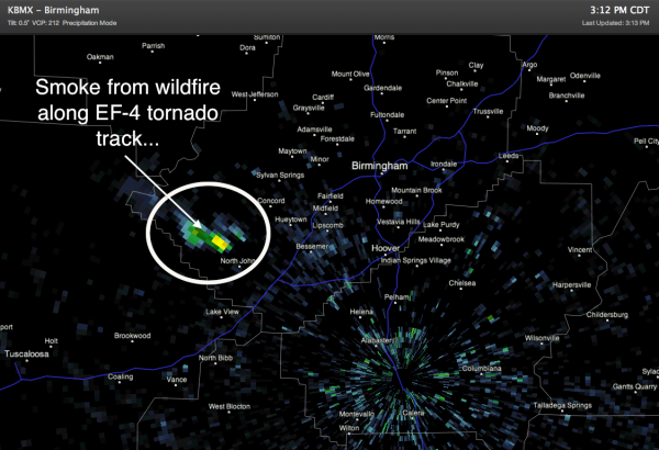
FIRE SHOWS UP ON RADAR: Remember the song “Smoke On The Water” by Deep Purple? Smoke In The Woods might be better lyrics today as wildfires continue to burn across our state. One of the biggest ones is in the EF-4 tornado track west of Concord, and the smoke plume is showing up nicely on BMX radar this afternoon… the smoke is the echo just northwest of North Johns…
TO THE SOUTH: Strong to severe storms have formed over South Mississippi, south of I-20, and a few isolated ones are over Southwest Alabama. But, nothing showing up this way for now. Temperatures are actually a notch lower today, but I don’t know if anyone can really tell the difference. Temperatures at 3:00 range from 93 at Gadsden to 97 at Muscle Shoals.
PERSISTENCE: I still don’t see much reason to change the forecast through the weekend. Hot hazy days, fair nights, and only isolated afternoon showers and storms at best. Widespread rain doesn’t look likely at all for the next seven days, and highs will remain in the mid 90s. See the post below this one for a better and detailed description of the routine summer weather we tend to see around here.
TROPICS: While the first tropical depression of the Eastern Pacific season has formed off the coast of Mexico below Acapulco, the disturbance in the Caribbean is sheared strongly, and tropical storm formation is not expected in the Atlantic basin through Friday.
AT THE BEACH: About 7 to 9 hours of sunshine each day through the weekend from Panama City to Gulf Shores with a few scattered thunderstorms possible. Highs on the immediate coast will be in the mid to upper 80s, with 90s inland. And, the SST (sea surface temperature) at the Dauphin Island Sea Lab this afternoon was a warm 86.5 degrees (F).
LONG RANGE: Watch the Weather Xtreme video and you will see the 12Z GFS wants to show a weakness in the upper ridge, with potential for some kind of tropical system moving into Alabama around June 18, but we all know that is most likely bogus as nice as it sounds. Persistence remains the best option at this point.
FOLLOW ALONG: Here are our weather team Twitter accounts….
| James Spann | Jason Simpson | Ashley Brand |
| J. B. Elliott | Bill Murray | Brian Peters |
| Dr. Tim Coleman | WeatherBrains Podcast | E-Warn (AL wx watches/warnings) |
WEATHER BRAINS: Don’t forget you can listen to our weekly 90 minute netcast anytime on the web, or on iTunes. This is the show all about weather featuring many familiar voices, including our meteorologists here at ABC 33/40.
Look for the next Weather Xtreme video here by 7:00 a.m. tomorrow…
Category: Alabama's Weather


