How do hurricanes achieve such strong winds?
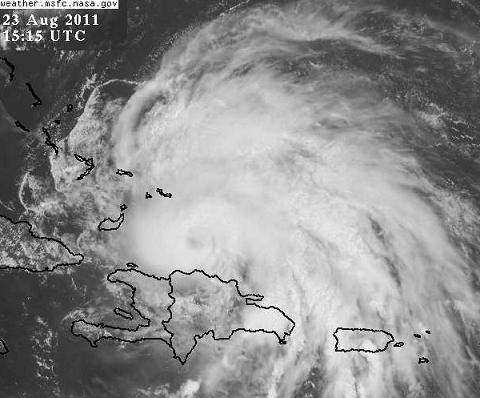
Since we’re all looking at Hurricane Irene, a storm that looks like it will affect the eastern seaboard and not the Gulf Coast, I thought this would be a good time to briefly discuss the thermodynamics of hurricanes.
What causes the winds in a hurricane is the extremely low pressure in the center, actually the gradient in pressure between normal, much higher pressures not far away from the very low pressure. Air rushes toward that low pressure, the Coriolis effect (spin of the earth) turns it right on the way in, so the hurricane spins counterclockwise.
But why does the pressure get so low, especially when air is flowing in toward the center? It has to do with the tall thunderstorms around the center of the hurricane. The air spiraling in at the bottom (near the ocean surface) is very warm and humid, and carries warm sea spray. This air then gets pulled upward around the center of the hurricane, creating unusually warm temperatures, often up to 20,000 feet or more in the atmosphere. Since all air cools somewhat as it rises (including the air that is already up there before the hurricane), a good measure of warm, moist air over the depth of the atmosphere comes from the equivalent potential temperature (theta-e). Basically, the higher theta-e, the warmer and more humid the air is. (Theta-e represents what temperature that air would have if all water was condensed out of it and then it was brought down to surface and warmed through the natural compression that occurs as air sinks)
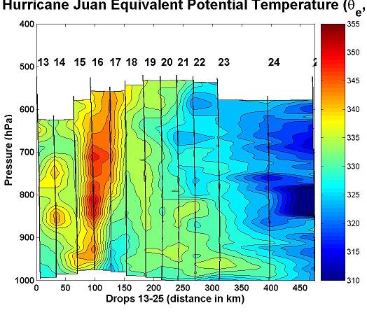
Below is a normal theta-e cross-section for today over southern California, and then the theta-e measured by dropsondes in a hurricane.
Notice that normal theta-e values aloft (near 800-500 mb, or 6,000 to 17,000 feet) are around 305 to 315 K (90 F to 108 F). However, in the hurricane, there is a tall, skinny area of very high theta-e, mainly between 335 K and 350 K (144 F and 171 F). This air is much warmer and more moist than the air all around it, and this air is, due to the ideal gas law, less dense.
The pressure at the ground is determined by the weight of the atmosphere above a point. When there is a large area of warm, humid, less dense air aloft, the pressure at the surface will be lower because the atmosphere above that point is lighter (less dense). So, it is the heat and humidity from the near-ocean air and sea spray that rises high into the hurricane, lowering the surface pressure, and causing winds to blow into the center.
This also explains why wind shear weakens hurricanes. In a wind shear environment, the storms will not be straight up and down, but tilted to the side, so the lowered surface pressure is spread out more, meaning less wind.
Category: Met 101/Weather History


Comments (34)
Trackback URL | Comments RSS Feed
Sites That Link to this Post