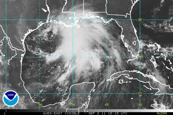
TD #13 Mid-morning Look
And…no, TD does not stand for “Touchdown!”
TROPICAL DEPRESSION 13 NORTH GULF OF MEXICO
A Flash Flood Watch is already in effect for almost all of Louisiana as well as Coastal Mississippi due to Tropical Depression #13. It will be a VERY slow-mover giving it time to dump enormous amounts of rain. It could produce 10-15 inches of rain over the next five days. Some places over Southeast Louisiana and Coastal Mississippi could indeed get as much as 20 inches setting off significant flash flooding. This is because the depreession currently is only moving at 1 mph.
A possible upside is that the ground is bone dry and rivers and streams are very low. So it would have to rain a lot to bring them up to bankfull.
The TD was almost stalled south of the Louisiana Coast about 200 miles SW of the mouth of the Mississippi River. It was moving (creeping) north at only 1 mph.
NWS has issued a Tropical Storm Warning from Pascagoula, Miss., west to Sabine Pass, Tex., and this includes the City of New Orleans.
The Governor of Louisiana has declared a State of Emergency for that state.
The long-range track forecast takes the center across South Mississippi into SW Alabama by late Tuesday night.
BIRMINGHAM METRO: While we will be getting a few showers and thunderstorms today and Saturday, it looks like our main time window for substantial rain will be Sunday/Monday/Tuesday. It is possible that we could get 4 to 5 inches during that time. That is not sealed in stone since that is 3 to 5 days down the road. In fact some models hint at 6 inches. But remember, the ground is bone dry and crying for rain. Rivers and streams are very low so it would take quite a bit of rain before the onset of serious flash-flooding. There is also the possibility (but highly unlikely) that the TD will stall over South Louisiana and dump most of its rain there.
In fact, one of our non-tropical models shows the center slowing or nearly stalling over North Central Alabama about Monday or Tuesday of next week. Too early to put all of our eggs in one basket.
COASTAL ALABAMA: Gulf Shores and Orange Beach will have numerous showers and thunderstorms all the way through Labor Day and into Tuesday. Very heavy rain amounts. A Flash Flood Advisory is already in effect for the entire area through Monday. A High Surface Advisory is posted until 7 am Tuesday.
Check this ABC 33/40 Weather Blog often over the next several days.. Not much sleep for the wary, but who needs sleep?
Category: Alabama's Weather, Tropical


