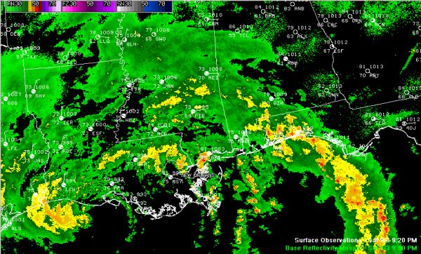
Lee Near The Louisiana Coast Still
HERE IS THE LATEST ON LEE:
BULLETIN
TROPICAL STORM LEE ADVISORY NUMBER 10
NWS NATIONAL HURRICANE CENTER MIAMI FL AL132011
1000 PM CDT SAT SEP 03 2011
…LEE STILL MEANDERING NEAR THE COAST OF SOUTHERN LOUISIANA…
SUMMARY OF 1000 PM CDT…0300 UTC…INFORMATION
———————————————–
LOCATION…29.4N 92.6W
ABOUT 85 MI…140 KM WSW OF MORGAN CITY LOUISIANA
ABOUT 65 MI…105 KM SSW OF LAFAYETTE LOUISIANA
MAXIMUM SUSTAINED WINDS…50 MPH…85 KM/H
PRESENT MOVEMENT…NNW OR 335 DEGREES AT 2 MPH…4 KM/H
MINIMUM CENTRAL PRESSURE…988 MB…29.18 INCHES
Tropical Storm Lee’s center continues to reform over and over as it hangs near the Louisiana coast this evening. It will begin moving northeast on Sunday and will be in southern Mississippi south of Jackson by Monday afternoon.
Rainfall amounts of 10-15 inches with isolated 20 inch amounts will occur from the Gulf Coast to the Tennessee Valley. Storm surge heights will be 3-5 feet above normal along the Louisiana coast and 1-3 feet along the Mississippi and Alabama coasts.
A few tornadoes are possible over southeastern Louisiana, southern Mississippi/Alabama into the western Florida Panhandle. This threat may spread into Central Alabama late tomorrow and Monday.
Tropical storm force winds will affect southeastern Louisiana into southern Mississippi and even southwestern Alabama through Monday. The winds should start diminishing on Monday and we shouldn’t see tropical storm force winds across Central Alabama, except perhaps in isolated gusts.
OUR IMPACTS: Heavy rain spread northward over South Alabama and into Central Alabama overnight. This heavy rain will move slowly northward across the area through tonight. Rainfall amounts will be around an inch or more west of I-65, with higher amounts (2-3 inches) the further west and southwest you go of a line from Hamilton to Tuscaloosa to Camden. There could be issues with flooding. There could be some tropical storm force winds over southwestern sections, perhaps as far north as Greene, Hale and Perry Counties. Wind advisories will likely be required for later today through Monday as winds over Central Alabama will increase to 15-25 mph starting late tonight into Monday. There is an outside chance of a small tornado in the outer bands of the tropical storm as they move northward today and Monday.
TUESDAY AND BEYOND: The remnant low from Lee will push northeastward on a path just south of I-59 through the day on Tuesday. There will still be a good chance of showers and some storms on Tuesday. They will begin to diminish late in the day as the low departs. There will be some clearing on Wednesday, but a few showers will hang around as the upper low that is associated with the remnants of Lee hangs around the Ohio Valley. As the upper low diminishes, shower chances will diminish to around 20% Thursday and less than that for the weekend.
COOLER TEMPS: One of the biggest benefits of Lee, besides the rain, will be cooler temperatures. We will be in the lower 80s on Sunday, upper 70s Monday middle 70s on Tuesday, upper 70s on Wednesday and just near 80F Thursday through Saturday. Lows Wednesday through Saturday mornings will be around 60F on average, with 50s in normally cooler spots.
Category: Alabama's Weather, Tropical


