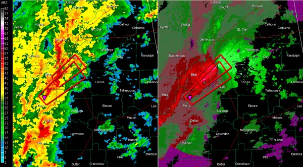
Recapping Alabama’s Weather at 1:15 p.m.
At this hour, moderate to heavy rain covers much of the western half of Alabama.
The line of heavy storms continues from the Birmingham metro south southwestward through western Shelby, Bibb, Perry, Dallas and Wilcox Counties. Be alert for heavy rain.
The strongest storms are northeast of Centreville and northeast of Marion. Tornado warnings are in effect ahead of these storms over Bibb, Shelby, Chilton and Perry Counties. They are moving northeast at 50-60 mph.
Folks in Montevallo, Calera, Columbiana and Alabaster need to be alert for the first Bibb County storm and folks just south of this from northeast of Marion up into Chilton County near Jemison and Thorsby need to be in safe shelter. Clanton is not in this warning.
A tornado or damaging winds are possible with these storms.
The chance for severe weather will be over South Central and East Central Alabama, south of I-20 and east of a line from east of West Blocton to Centreville to Marion and Pine Hill. The best chance for a tornado will be from Bibb, Shelby, Talladega, Clay and Randolph Counties and points south.
Greene, Sumter and Tuscaloosa Counties have been cleared from the Tornado Watch. Areas ahead of the line of storms up into North Alabama continue under a tornado watch until 5 p.m.
We have a very strong temperature and dewpoint gradient across Central Alabama this afternoon, extending from a low pressure center near Birmingham. A warm front extends eastward out of the low along I-20. A sharp cold front extends south southwestward just behind the main line of strong storms.
Category: Alabama's Weather, Severe Weather


