Afternoon Update
Showers and thunderstorms are starting to form this afternoon along a northward moving warm front. It separates temperatures and dewpoint in the 50s from 70+ degree temps and 65+ degree dewpoints that are lifting on a strong southerly flow ahead of a powerful upper levels trough and surface low to our northwest. Instability values over South Alabama are running ove 1,000 j/kg now. Negative lifted index values are about as far north as US-82 in Alabama.
The storms are over Southeast Alabama, southeast of Montgomery now. They will lift up I-85 over the next couple of hours.
Showers and developing now over much of the rest of Alabama and eastern Mississippi in the strong warm advection pattern. You can expect scattered showers over the next several hours. Watch for development over Central Mississippi in the next couple of hours. The Alabama and Mississippi storms will continue to intensify and expand. Some of them near the warm front could become severe, with the potential that they could produce tornadoes. We will monitor them carefully. Look for them between 6-10 p.m., especially over Northwest Alabama.
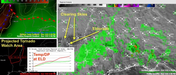
The SPC will issue a tornado watch before 6 p.m. for parts of Arkansas, northern Louisiana, western Tennessee and northwestern Mississippi. The general expected area for the first watch is shown in the lower left panel of the graphic with this story. Click the graphic to enlarge it.
You can see some clearing that has occurred over southern Arkansas, northern Louisiana up into Northwest Mississippi. Dry air aloft is helping this clearing to occur. That is another bad ingredient in the mix. In the first few thousand feet of the atmosphere, there is lots of moisture. The dewpoint at Eldorado, AR (station ID ELD on the weather map in the right side panel) jumped 9 degrees in one hours from 55F to 64F! The temperature has soared to 73F with a strong south wind averaging 14 mph and gusting to 25 mph.
Storms will fire in the next couple of hours in this region from Shreveport to Little Rock and Memphis and move quickly northeast. These storms will be supercells and will have a significant tornado producing potential. The potential supercells will continue pushing east overnight across northern Mississippi. Some of those supercells could get into Northwest Alabama after 10 p.m. tonight.
Eventually the storms will congeal into a powerful squall line ahead of a cold front that will push into Alabama late tonight. Hopefully the supercells will merge into that squall line before they have a chance to get into Alabama late tonight (after midnight). It now looks like that powerful line of storms will reach Northwest Alabama around 3 a.m., Jasper around 4:30 a.m., Tuscaloosa around 6 and Birmingham around 7. Do not take these times as gospel though as those times will likely change.
So in summary:
…Look for increasing showers and storms over the next 3-4 hours across Central Alabama ahead of a warm front. These storms could become strong and a couple could be severe, especially over Northwest Alabama. It will get warmer and more humid as we get into the evening and the southerly wind will pick up to between 10-20 mph.
…Supercell storms in northern Mississippi could get into Northwest Alabama after 10 p.m. or so. These storms will have the potential to produce tornadoes.
…A powerful line of storms with damaging winds and the potential for isolated tornadoes will cross the state during the early morning hours, starting in Northwest Alabama around 3 .m., reaching the I-59 corridor between 6-8 a.m and exiting into Georgia by lunchtime.
BOTTOM LINE
It is a night where you will want to make sure you have a source of warning information that will wake you up. You need to review your safety plans, and think of where your safe places will be wherever you are.
We will have frequent updates on the blog and of course, you will be able to turn to us for wall to wall severe weather coverage on ABC3340 when the first tornado warning is issued for our area.
Category: Alabama's Weather, Severe Weather


