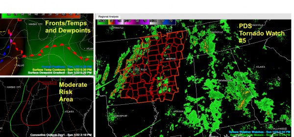
PDS Tornado Watch Issued to Our West
The SPC has issued Tornado Watch #5 for portions of western Tennessee, much of eastern Arkansas and northwestern Mississippi. It is in effect until midnight.
It is a PDS watch, meaning a “particularly dangerous situation”. The SPC issued a PDS watch when there is an enahnced threat of life threatening severe weather.
The watch is shown in the right panel with the current composite radar. Storms have developed rapidly in the past 90 minutes over Arkansas. The leading edge of those storms bisects the state from northeast to southwest from west of Harrison to just west of Little Rock to near Texarkana. Those storms have a significant chance to produce strong tornadoes over the next few hours in the watch area.
The warm front is all the way through Mississippi now and is passing Birmingham. South of the front, you will feel the difference, as dewpoints are about 5-6 degrees higher, making it feel more humid.
Radar is still relatively quiet across Alabama and Mississippi. There are some light showers over Mississippi and an area of widespread moderate showers over the southeastern quarter of Alabama, generally south of I-59 and east of I-65.
An earlier storm in Marengo County did produce a wall cloud (scroll down for images). That cell has weakened to a shower and is now moving into Bibb County. It is not a threat.
No change in our thinking, except that the activity along the warm front has not been a factor fortunately.
Showers and storms will develop in the warm sector over Mississippi and Alabama ahead of the main activity during the late evening hours after 8-9 p.m. Those storms do have the potential to become severe with strong wind shear in place. Damaging wind and hail are the main threats with a chance of a tornado.
The main line of storms will reach west Alabama after midnight, probably reaching the Northwest corner of the state around 2 a.m., Marion County around 3 a.m., Walker County before 4 a.m., Tuscaloosa by 5 a.m. and Birmingham. It should reach Gadsden by 7 and Anniston by 7:30 a.m. Remember, these times are estimates. Squall lines are like AMTRAK trains, they rarely stick to the schedule. This line will have good probability of damaging winds and isolated tornadoes.
Hail will be a threat tonight, as will heavy rain and lightning of course.
Review your personal safety plan, stay in close touch with a reliable source of warning information and be ready to take action when warnings are issued for your location. Stay aware, stay alive!
Category: Alabama's Weather, Severe Weather


