Severe Weather Update…Sunday Noon
The 12z model data is in and it does not change my thinking very much…
The highlights are that a dynamic storm system will bring a threat of severe weather to Alabama between 8 p.m. Monday night and 8 a.m. Tuesday morning.
A deep upper level trough will be swinging across Texas on Monday. A developing surface low will move from Northeast Texas to southern Arkansas by noon, then to Memphis by sunset and to Nashville around midnight. Our winds will start to pick up out of the southeast tomorrow and it will become quite breezy.
The wild card is instability…it will certainly be warm on Monday, with highs well into the 70s and a good bit of sunshine. There wil actually be a cap in place that will help to keep a lid on the pot until late afternoon. The missing ingredient may be rich moisture. Dewpoints are forecast by the models to only get into the upper 50s Monday night. This may be low. If we get dewpoints in the lower and middle 60s, the potential energy nearly triples!
If this happens, we will see the development of supercell storms Monday evening. These have a higher potential for producing tornadoes.
All through the vertical profile of the atmosphere, the winds will be screaming by Monday evening, with winds of nearly 100 mph at 18,000 feet and nearly 150 mph at 30,000 feet. This will create tremendous shear in the atmosphere. The question is instability.
So, if dewpoints get into the lower and middle 60s, instead of upper 50s to around 60, we might be looking at significant supercells and tornadoes. The moderate risk area issued for tomorrow comes right to our western border and we are currently in a slight risk area. Could be upgraded for us later as the situation unfolds.
Here is the updated Day Two outlook…
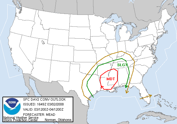
The Storm Prediction Center is very bullish on this system…
–WIDESPREAD SEVERE WEATHER IS EXPECTED ACROSS THE LOWER MS VALLEY
MONDAY AND MONDAY NIGHT WITH THE POTENTIAL FOR DAMAGING WINDS AND A
FEW SIGNIFICANT TORNADOES.–
So is the NWS Birmingham…
THE BIG SHOW COMES MONDAY NIGHT. SPC HAS US IN A SLIGHT RISK
AREA…ALTHOUGH WE ALSO NOTE THAT THE HATCHED 30 PERCENT AREA
EXTENDS ARE FAR EAST AS BHM AND ALMOST TO SELMA…AND THE MDT RISK
(AND THE HATCHED 45 PERCENT) IS RIGHT ON OUR DOORSTEP. THE
SYNOPTIC PATTERN PREDICTED BY THE MODELS CERTAINLY SUGGEST A
FAIRLY HIGH POTENTIAL FOR SEVERE WEATHER. MOISTURE AND LIFT WILL
NOT BE LACKING MONDAY NIGHT…AND A 70+ KNOT LOW LEVEL JET CANNOT
BE IGNORED. THERE`S SHEAR A-PLENTY…BUT THE MODELS ONCE AGAIN
SEEM TO HOLD BACK ON THE INSTABILITY. IF ONE WERE TO TWEAK THE
DEWPOINT AT BHM AT 21Z MONDAY FROM 58F (AS FORECAST) TO 62F (WHICH
IS CERTAINLY POSSIBLE)…THEN THE SBCAPE JUMPS FROM LESS THAN 700
TO MORE THAN 1600. I`M NOT ALL THAT COMFORTABLE IN ASSUMING THAT
DEWPOINTS WILL ONLY MAKE IT INTO THE 50S…AND EQUALLY UNEASY
ABOUT HOW MUCH TEMPS FALL AFTER SUNSET MONDAY (GIVEN THE STRENGTH
OF THE LOW LEVEL WINDS). NOT TO MENTION THAT IT IS MARCH…AND
CLIMATOLOGICALLY THIS BEGINS THE HEART OF OUR SEVERE WEATHER
SEASON.
As the upper trough swings around and becomes negatively tilted Monday night, the system will switch to more of a powerful squall line with the potential to produce widespread wind damage. The difference in this one and the one earlier this week is that it will be much more powerful as it enters Alabama. There will be the potential for isolated tornadoes also, much like the other night.
But I want you to be as concerned about a 70-100 mph straight line wind event as you are an EF1 tornado. They do the same damage folks.
Let’s be ready with our weather radios and personal safety plans. Check your batteries. Make sure your SAME alert codes are entered correctly. Rehearse your severe weather plan with your family.
We don’t want any injuries or fatalities from this event. Middle of the night events are particularly scary. Arm yourself with information.
Category: Uncategorized
About the Author (Author Profile)
Bill Murray is the President of The Weather Factory. He is the site's official weather historian and a weekend forecaster. He also anchors the site's severe weather coverage. Bill Murray is the proud holder of National Weather Association Digital Seal #0001 @wxhistorianSubscribe
If you enjoyed this article, subscribe to receive more just like it.


