Chaser Convergence
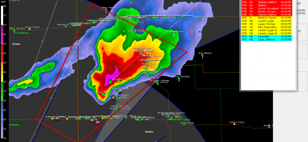
Terry Sasser sent us this image from his Gibson Ridge with Spotter Network activated showing all of the chasers lined up across southern Kansas earlier today.
There have been over two dozen reports of tornadoes today so far.
And the event is just getting started. The extremely high winds aloft are just nosing into Kansas. The storms over Kansas and much of Oklahoma will begin to intensify rapidly over the next couple of hours and large tornadoes will result.
Nebraska State Troopers are tracking a tornado on the ground very near North Platte right now.
At 5:37, NWS Wichita reported wedge tornado in progress near Pollard in Rice County KS. Another report shows large wedge on the ground 4 miles south of Geneso in Rice County.
Same storm: from Matt Gingery (via spotternetwork.org) @ 05:36 PM CDT — (S) Tor — — Spotter is 2 miles N of Mitchell, KS (Rice county) [38.418/-98.090] — Extremely large and violent tornado to my west. Dangerous situation. Notify public (SN#11089)
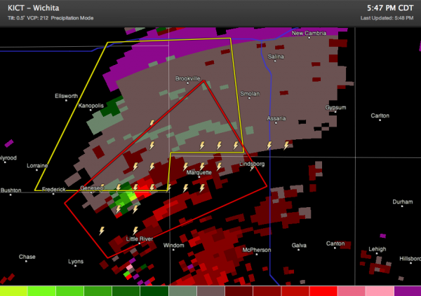
Here is a radar image at 5:47 showing the strong rotation:
Our friend Dave Freemean is on the air on KSN. Follow their streaming at https://www.ksn.com/content/weather/liveradar.aspx.
A big tornado watch has just been issued that extends from Nebraska to Texas.
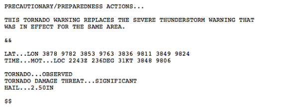
Here is one of the new types of tornado warnings being tested in the NWS Central Region. Notice the tages toward the end of the message.
000
WFUS53 KICT 142243
TORICT
KSC053-113-159-169-142330-
/O.NEW.KICT.TO.W.0016.120414T2243Z-120414T2330Z/
BULLETIN – EAS ACTIVATION REQUESTED
TORNADO WARNING
NATIONAL WEATHER SERVICE WICHITA KS
543 PM CDT SAT APR 14 2012
THE NATIONAL WEATHER SERVICE IN WICHITA HAS ISSUED A
* TORNADO WARNING FOR…
SOUTHEASTERN ELLSWORTH COUNTY IN CENTRAL KANSAS…
NORTHWESTERN MCPHERSON COUNTY IN CENTRAL KANSAS…
NORTHEASTERN RICE COUNTY IN CENTRAL KANSAS…
SOUTHWESTERN SALINE COUNTY IN CENTRAL KANSAS…
* UNTIL 630 PM CDT
* AT 542 PM CDT…A CONFIRMED LARGE AND EXTREMELY DANGEROUS TORNADO
WAS LOCATED 5 MILES SOUTHEAST OF GENESEO…AND MOVING NORTHEAST AT
35 MPH.
THIS IS A PARTICULARLY DANGEROUS SITUATION.
HAZARD…DAMAGING TORNADO.
SOURCE…LAW ENFORCEMENT CONFIRMED TORNADO.
IMPACT…MAJOR HOUSE AND BUILDING DAMAGE LIKELY AND COMPLETE
DESTRUCTION POSSIBLE. NUMEROUS TREES SNAPPED. MAJOR POWER
OUTAGES IN PATH OF TORNADO HIGHLY LIKELY. SOME ROADS
POSSIBLY BLOCKED BY TORNADO DEBRIS. COMPLETE DESTRUCTION
OF VEHICLES LIKELY.
* LOCATIONS IMPACTED INCLUDE…
MARQUETTE AND LINDSBORG.
PRECAUTIONARY/PREPAREDNESS ACTIONS…
THIS TORNADO WARNING REPLACES THE SEVERE THUNDERSTORM WARNING THAT
WAS IN EFFECT FOR THE SAME AREA.
&&
LAT…LON 3878 9782 3853 9763 3836 9811 3849 9824
TIME…MOT…LOC 2243Z 236DEG 31KT 3848 9806
TORNADO…OBSERVED
TORNADO DAMAGE THREAT…SIGNIFICANT
HAIL…2.50IN
$$
BILLINGS
Category: Headlines, Severe Weather


