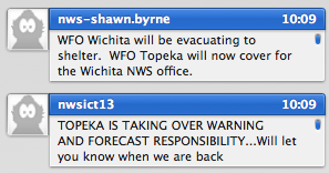
Tornado Moving into Wichita, NWS Evacuates
LATE REPORT:
from Tim Marquis (via spotternetwork.org) @ 10:15 PM CDT — (S) Tor — — Spotter is 3 miles SE of Peck, KS (Sumner county) [37.449/-97.332] — Large wedge tornado approximately 3 miles to my north. (SN#1117
10:16
ANOTHER
Tyler Costantini (via spotternetwork.org) @ 10:15 PM CDT — (S) Other — — Spotter is 1 miles S of Derby, KS (Sedgwick county) [37.525/-97.269] — I am seeing several power flashes to our NW in the direction of Hayesville aprox 5 miles away.. (SN#11180)
AT 10:23
Power just went out in southwest Wichita. Visible on the KSN skycam.
MORE REPORTS
from Donovan Gruner (via spotternetwork.org) @ 10:21 PM CDT — (S) Tor — — Spotter is 1 miles S of Wego-Waco, KS (Sedgwick county) [37.501/-97.334] — Wedge tornado and powerflashes observed five minutes ago three miles north
Gene Yates (via spotternetwork.org) @ 10:22 PM CDT — (S) Tor — — Spotter is 1 miles NE of Wego-Waco, KS (Sedgwick county) [37.529/-97.324] — Large tornado crosses 35 2 miles ahead of us we are at mile marker 37 multiple power flashes near haysville. (SN#11182)
10:23
noaa-kiel.l.ortega left the roo
Category: Headlines, Severe Weather


