Busy Day Ahead for Georgia
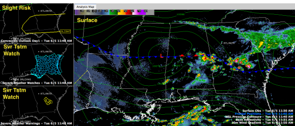
Storms have formed late this morning in the unstable air ahead of a southward moving cold front that is lying across Central Alabama.
They are heavy, but not severe.
There have been significant weather advisories for parts of Russell and Randolph Counties in East Central Alabama for the storms there between Alex City and Columbus GA.
There is also a weak surface low traversing from west to east across the state along the front. That is enhancing the storms.
The SPC has roughly the southeastern half of Alabama and the southern half of Georgia into northern Florida under a slight risk convective outlook. This is their standard forecast for severe weather. There is decent instability ahead of the front and decent wind shear, or change in wind velocity with height, to support organized storms, even supercells.
There is even a severe thunderstorm watch in Georgia and the extreme southeastern corner of Alabama as well as parts of northern Florida. The NWS in Atlanta has issued a few severe thunderstorm warnings.
There could be a few storms up to I-20 through 4 p.m., with the cells going downhill quickly after that. They should all be gone by 8:30 p.m. The best chance for storms will be southeast of that surface low as it tracks slowly east.
The stronger storms could produce gusty winds, heavy rain, lots of lightning and maybe some small hail. The Alabama tornado threat is nearly zero. There is a low threat in Georgia.
Category: Alabama's Weather, Severe Weather


