Working on Clearing the Notebook
Mark Rose at the NWS reports that lightning detection systems have counted 4,000-7,000 cloud to ground lightning strike per hour since midnight across Alabama.
Doug Bennett relays report of flooding in Odenville at the railroad overpass, road flooded.
Tree blocking Riverchase Parkway in Hoover.
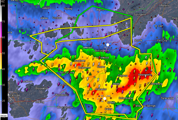
At 5 a.m., the strongest storms were in Shleby County from Harpersville to Clumbiana.
1.89 inches of rain at the Birmingham Airport as of 4:53 a.m. Peak wind gust at the airport 44 mph.
There are strong winds behind the line of storms in Birmingham now. Sustained 20-30 mph here in Trussville with gusts to near 40 mph. Feels like a gravity wave. .
John Talbot in Hueytown reports 2.73 inches.
Here is the radar at 5:05. The second line is catching the first one and it will now weaken. The NWS does not expect to issue any more severe thunderstorm warnings. The threat now will be continued flooding problems.
Severe thunderstorm watch continues until 7 a.m.
Severe thunderstorm warning canceled for Walker, continues for Jefferson, Chilton and Shelby until 6 a.m.
Flash flood warnings for Jefferson and Shelby Counties.
Slight risk today goes into effect at 7 a.m. It includes areas generally along and south of I-59.
Looking upstream, more storms are forming across southern Tennessee back into the Memphis area. We could deal with those a little later.
Category: Alabama's Weather, Severe Weather


