8 a.m. Notes
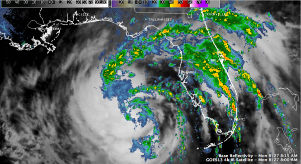
Isaac appears to be developing an eyewall this morning according to the Hurricane Hunters. A center structure is evident on radar from Tampa, which is looking pretty high up into the storm.
Satellite imagery has shown an apparent center feature developing as well. This rainband will spread across the Panhandle to near Destin and into Southeast Alabama by early afternoon. It won’t make it any further than Troy and Auburn before it dissipates this evening. We will stay dry in Central Alabama. Our first showers and storms should develop tomorrow. It will become cloudy tomorrow during the day with a breezy east wind averaging 10 mph.
You can see that the outer rainband is approaching Apalachicola and Tallahassee now.
Top winds are still 65 mph. The central pressure continues to slowly fall, now at 989 mb.
The early cycle track guidance for 12z is in, and it seems to favor the current NHC track right up the Mississippi River and across New Orleans.
There are two planes in the storm right now, providing observations. One of them just located the center. We should have a vortex data message shortly.
Category: Tropical


