Isaac Still A Tropical Storm
An all new edition of the ABC 33/40 Weather Xtreme video is available in the player on the right sidebar of the blog. You can subscribe to the Weather Xtreme video on iTunes by clicking here.
Don’t forget to watch the Weather Xtreme video for all of the graphics and additional details that go along with this discussion.
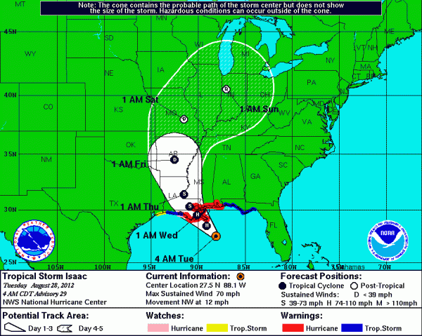
NOT A HURRICANE: Issac continues to have a hard time this morning, and NHC keeps the system below hurricane strength. The satellite presentation is less than impressive, with dry air eating away at some of the inner convection and a lopsided appearance. Maximum sustained winds remain at 70 mph, and the center is moving NW at about 12 mph. The center should make landfall within 12 to 15 hours.
COASTAL IMPACT: A minimal hurricane will not create much structural damage along the coast. It will knock down some trees and power lines, and there will be some power outages, of course, from New Orleans over to Pensacola.
NHC projects a 6 to 12 foot storm surge over SE Louisiana and Mississippi; 4 to 8 feet along the Alabama coast, so there will be some coastal flooding, but the biggest issue is the rain. Rain totals of 10 to 20 inches are possible from New Orleans over the Orange Beach. Hopefully the drier air in the circulation will keep the rain totals closer to 10 inches, but even that will produce some extensive flooding, and people in low lying areas need to be aware of this and ready to move to higher ground in a heartbeat.
INLAND IMPACT: For our part of Alabama, we will be on the wet/unsettled side of Isaac in coming days. With the very slow movement of Isaac during the first 24 hours inland, I am beginning to think now our most widespread rain will come on Thursday, but no doubt we will have occasional tropical showers today, tonight, and tomorrow.
The guys at HPC (the Hydrometeorological Prediction Center) have really brought the expected rain amounts down for the northern half of Alabama; they have Birmingham, Tuscaloosa, Anniston, and Gadsden in a 1-2 inch zone this week, with the heavier totals to the south and west. Should this be correct that could lessen any risk of flooding issues here, of course, but I think there is potential we get more, and I believe 2 to 4 inches is a more correct solution at this point between now and Friday. But even that probably won’t bring too many flooding problems.
The heaviest rain (inland) will come south of a line from Reform to Tuscaloosa, and then down U.S. 82 to Maplesville and Montgomery, and then to Andalusia. This part of the state (away from the coast) can expect 5 to 10 inch amounts, and some flooding there is a very real possibility for places like Butler, Grove Hill, Monroeville, and Atmore.
TORNADO THREAT: We will have some risk of small, isolated tornadoes in the spiral bands wrapping around the center of Isaac. Tomorrow, the highest risk of these should be along and south of U.S. 84, down across the southern quarter of Alabama. But, on Wednesday, SPC has the “slight risk” as far north as Hamilton, Birmingham, and Opelika. Much of North Alabama will have some risk of isolated tornadoes on Thursday as Isaac gains latitude.
Understand any tornadoes this week will be small, short-lived, low-topped, and a great challenge for those working the warning desk at NWS offices. Not like the big tornadoes of spring and fall, but they can still produce damage and can be a real threat. Be listening for tornado warnings and make the appropriate response.
GRADIENT WIND: Like we have mentioned here in recent days, with the center of Isaac remaining well to the west, and it being a minimal hurricane at the time of landfall, we do not expect too much in the way of gradient wind issues or power outages over the northern half of Alabama. Winds will be in the 15-25 mph range tomorrow and Wednesday, but that rarely causes major issues here other than a few limbs down.
TRAVEL: I really don’t expect any major problems at Birmingham-Shuttlesworth Airport this week… there could be a few ground stops along the way, but delays should be limited. And, if you are driving to Dallas for the Alabama game, or Atlanta for the Auburn game, no doubt it will be a wet drive (especially the Dallas drive), and you will need to be listening for any possible flooding issues or tornado warnings, but you should make it fine.
SCHOOL CLOSINGS: Don’t expect any around here this week. Sorry, kids.
LABOR DAY WEEKEND: While Isaac will be long, a very moist, tropical airmass will linger across the Deep South. If you are hanging around here, or going to the coast, it won’t rain all weekend long, and the sun will be out at times, but just be aware a passing shower or storm will be possible at just about any time. Highs will be mostly in the upper 80s in the very humid air through Monday.
WEATHER BRAINS: Don’t forget you can listen to our weekly 90 minute netcast anytime on the web, or on iTunes. This is the show all about weather featuring many familiar voices, including our meteorologists here at ABC 33/40. Scroll down to see the show notes for this week’s new show we recorded last night.
CONNECT: You can find me on all of the major social networks…
We will keep the blog updated throughout the day as Isaac gets closer to the coast… the next Weather Xtreme video will be posted by 3:30 or so this afternoon. Enjoy the day!
Category: Alabama's Weather


