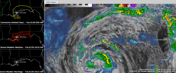
10 a.m. Update
Issac is trying unsuccessfully still to become a hurricane.
It certainly has a central pressure that would rival any category one hurricane. But that’s not how we keep score in tropical circles.
It certainly has flight level winds that you would see in a category one hurricane. But that’s not how they’re classified either.
It’s on surface winds. And despite the low pressure and the flight level winds, winds at the surface continue to be around 60-70 mph. Kudos to the Hurricane Center for sticking to their guns and waiting to pull the trigger.
Every time it seems that Isaac is getting its act together with an inner core, drier air comes in and soaks up the convection like a sponge, and the cycle starts over again.
It only has about 12 hours until landfall, which should come this evening around Barataria Bay, west of Buras, LA.
Even though it is not a hurricane, it is still a formidable storm. It will deliver tremendous rains to a wide area of the southern U.S. as it slowly makes landfall tonight and moves up into Arkansas tomorrow night. Near the coast, rainfall amounts of six inches or more will cover much of southeastern Louisiana, southern Mississippi and Southwest Alabama, will locallized amounts approaching 20 inches!
As the storm lifts out to the north and northeast, a wide swath of 3-6 inch amounts will spread across eastern Arkansas, southeastern Missouri, Illinois, Indiana and into Ohio. This will be a Godsend to that drought parched area.
The persistent southerly winds on the eastern side of the storm continues to pile water up against the gulf beaches from southeastern Louisiana to Northwest Florida. Tides may reach as high as 6-12 feet over Louisiana and the Mississippi coast, with 6-9 fete along the Alabama coast.
A tornado watch is in effect along the Gulf Coast from Southeast Louisiana to the Panama City area.
Further north, across Central Alabama, the impacts are going to be from feeder bands that will produce heavy showers and some storms that might spin up a few isolated tornadoes tomorrow up to the US-78/280 corridor. Rainfall amounts should average 1-2 inches in the I-20 corridor, with higher amounts as you go southwest.
One of those feeder bands right now extends generally along I-20 from Pickens County to Birmingham to Cleburne County in East Alabama.
Winds should pick up to about 10-20 mph tomorrow and perhaps 15-25 on Thursday in our area.
Mobile just reported an ESE wind at 35 gusting to 47 mph as a rainband is passing through.
COASTAL REPORTS
…West end of Dauphin Island flooded
…Dauphin Island – east end: gusting to 45 mph
…Fort Morgan: east wind gusting to 44 mph
…New Orleans: NE wind 24 gusting to 35 mph
…Destin: E at 22, gusting to 35 mph.
…Some flooding reported in downtown Panama City
…52 mph gust at Buras (near the mouth of the Mississippi River)
Category: Alabama's Weather, Tropical


