SPC Day One
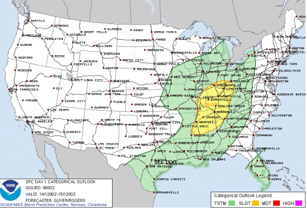
The Storm Prediction Center has issued their day one severe weather outlook, and it includes parts of Northwest Alabama, generally north of a line from Millport to Jasper to Cullman and Scottsboro. It will go into effect at 7 a.m. CDT and remain in effect until 7 p.m. CDT.
In the upper levels of the atmosphere this morning, we find a strong trough of low pressure approaching the Mississippi River. A surface low is over southeastern Iowa, with a cold front trailing back through northwestern Arkansas and on into North central Texas. Storms that were strong to severe over Kansas, Oklahoma, Texas, Missouri and Arkansas yesterday afternoon and evening weakened as they pushed east overnight. They literally ran out of gas as they ran into more stable air over eastern Arkansas and Louisiana. Showers and storms are lined up from near Memphis to Shreveport this morning. The low will continue to move to the northeast, taking the better dynamics with it, but we still will deal with showers and storms later today and tonight across Alabama.
You can expect some sunshine, at least this morning, even as clouds increase from the west. Temperatures should warm into the upper 70s by lunchtime and will top out between 79F-81F during the afternoon. You will notice that southerly breeze freshening again during the morning hours, averaging 10-15 mph, with occasional higher gusts. Dewpoints are in the middle 60s, so combined with the breezy, warm conditions, the atmosphere will have a bit of a severe weather feel to it.
A few showers will work into western Alabama by early afternoon, but they shouldn’t be heavy, or even have any thunder for that matter. Storms will start to build over Central Mississippi by midafternoon and will push towards Alabama. They should arrive in Northwest Alabama between 4-6 p.m. Instability values will climb to around 250-500 j/kg by late afternoon and early evening, with some 500+ j/kg further to the southwest. This will be sufficient for thunder of course, but will be insufficient to produce really big thunderstorm updrafts. There will be at least 30 knots of bulk shear, meaning the updrafts will be sustained. Storm Relative Helicity will be less than 150 m2/s2, and decreasing, so the threat for tornadoes will be small. We do note that the SPC has a slight risk forecast out down into Northwest Alabama for areas north of a line from Millport to Jasper to Decatur.
The broken line of showers and storms will reach the I-59 corridor around 10 p.m. They should continue to weaken overnight. By Monday morning, they will be near the I-85 corridor. Morning readings will average out around 60F, as the cooler air won’t really arrive until later in the day on Monday.
Category: Alabama's Weather, Severe Weather


