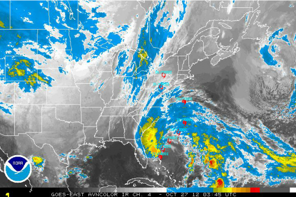
Late Night Look At Sandy
Looking at a satellite picture tonight, Hurricane Sandy doesn’t look like much. In fact, by morning, it will probably officially be a tropical storm. But don’t let that fool you.
The pressure in the storm will begin to drop later today as deepening occurs due to baroclinic processes. In English, that means that the system will start to intensify as cold air and warm air start to mix, the different densities helping to spin up the storm.
The center is a little less than 300 miles east southeast of Jacksonville this morning. It is moving northeast at 10 mph right now, and you would think that would mean a good thing, taking it out to sea. The center will nearly follow the curve of the coastline of the U.S. until Monday, when it will make a hard left turn and approach the coast.
Sandy will regain hurricane strength tomorrow, according to the official forecast. The system will make the transition from tropical to cold core over the next couple of days. But that doesn’t mean areas to be impacted will be able to let their guard down. The wind field will expand, meaning tropical storm, strong tropical storm and even hurricane force winds will be felt over a wide area.
Strong winds should remain east of the coasts of Florida and Georgia. Tropical storm force winds will reach the coasts of South and North Carolina Saturday night as the radius of 39+ mph winds grows to 300 miles. They will expand over eastern North Carolina Sunday.
The predicted hard left turn should commence by noon Monday, and by then tropical storm force winds will cover much of the East Coast from Wilmington to north of Boston. That’s 700 miles wide!!!!
By Monday night, strong tropical storm force winds (>58 mph) will impact the area from the Chesapeake to the New Jersey Coast. The strong tropical storm force winds should reach New York City by late Monday evening.
As the center reaches the Delaware Bay late Monday night, hurricane force winds will impact areas from near Washington DC to New Work City late Monday night into Tuesday morning.
This will cause widespread tree and power line damage. Power outages will be extensive and could last for an extended period.
Coastal flooding will be severe, especially where onshore flow piles water against the coast. Extensive damage to coastal structures will occur. Water levels will rise in bays and tidal estuaries, causing coastal flooding.
Rainfall amounts will total 6-12 inches across the Mid-Atlantic into Central Pennsylvania up to New York City, presenting the threat of flooding.
Travel delays will be a big problem on Monday and Tuesday at airports from Washington and Baltimore to New York City and Boston.
BIG TIME SNOW: The National Weather Service in Charleston WV maintains a Winter Storm Watch from Sunday night through Tuesday morning. 10-14 inches of snow is forecast for the mountains of the Mountaineer State around Elkins and Snowshoe. At least the skiers will be delighted.
Category: Tropical


