Warnings Soon for West Alabama
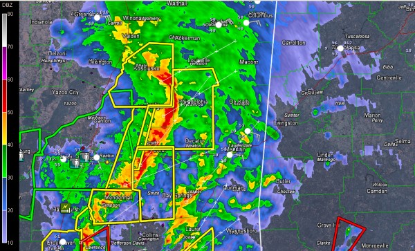
Severe storms are just over an hour west of Pickens, Sumter and Greene Counties.
They are trailing from a comma head shaped quasi-linear convective system now approaching Louisville and Philadelphia MS.
The complex is moving east northeast at 50 mph.
Look for warnings to be issued for western Alabama counties by 4:30 or so.
On its current trajectory, it will affect Tuscaloosa around 6 p.m. and Birmingham and hour later.
Two separate tornado warnings are in effect for Clarke/Monroe Counties in Southwest Alabama and Covington/Crenshaw Counties in South Alabama.
The tornado watch has been extended eastward to include the Montgomery area.
In Mississippi, tornado damage has been reported in Pearl River County. These storms will move toward Washington and northern Mobile Counties.
Category: Alabama's Weather, Severe Weather
About the Author (Author Profile)
Bill Murray is the President of The Weather Factory. He is the site's official weather historian and a weekend forecaster. He also anchors the site's severe weather coverage. Bill Murray is the proud holder of National Weather Association Digital Seal #0001 @wxhistorianSubscribe
If you enjoyed this article, subscribe to receive more just like it.


