On the Maps
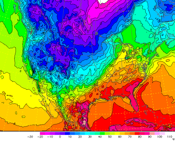
Temperature analysis for this afternoon, shows plenty of warm air has moved north from the Gulf of Mexico with 60s reaching into the Ohio River Valley. Much of Alabama is in the 70s with some areas approaching 80. There is a lot warm air across the eastern sections of the U.S., while locations in the west are frigid. You can almost see where the front is on this map, you will notice a tighter temperature gradient from eastern Illinois down through Missouri and Arkansas. The colder air will be slowly working towards us the next 48 hours.
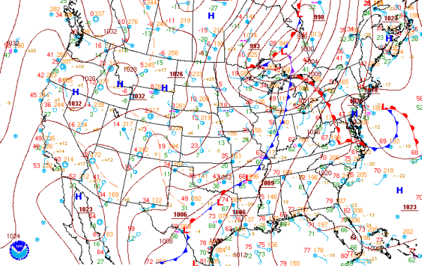
On the surface analysis, you can see that the front is lined up along the gradient in the temperature analysis. Front is moving a bit more quickly on the northern end of it. The front is a bit more slower to near stationary from Arkansas into Texas. Several areas of surface low pressure along the southern end of the front is providing a bit of extra shear across the area. This is where we are looking at some strong and severe thunderstorms this afternoon. The slow movement will continue to allow for heavy rain to fall on saturated ground, so flooding will continue to be a threat. Once the front moves through, high pressure will eventually settle in from the west bringing colder and more seasonable temperatures.
Category: Alabama's Weather
About the Author (Author Profile)
Macon, Georgia Television Chief Meteorologist, Birmingham native, and long time Contributor on AlabamaWX. Stormchaser. I did not choose Weather, it chose Me. College Football Fanatic. @Ryan_StinnetSubscribe
If you enjoyed this article, subscribe to receive more just like it.


