

Snow Moving into Birmingham
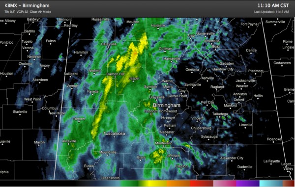
Much of West Alabama is picking up moderate to heavy snow at this hour.
The snow is heaviest over Winston, southeastern Marion, much of Walker, Fayette, Pickens and northern Tuscaloosa.
It is now into Jefferson County and will spread across the Birmingham Metro in the next hour.
Some moderate to heavy snow is falling north over eastern Bibb into southwestern Shelby and western Chilton Counties between Montevallo, Brent and Jemison. Big snowflakes reportedly falling Calera now.
Folks in the heavier snow areas will pick up a burst of snow that will dump about an inch pretty quickly, sticking on cars, roofs and grassy areas. If it continues to snow for an hour or so, it will begin sticking to roads. Bridges and overpasses will become slushy quickly.
Walker County EMA is asking folks not to drive…
DUE TO HEAVY SNOWFALL OVER THE LAST COUPLE OF HOURS…ROAD
CONDITIONS HAVE DETERIORATED CONSIDERABLY CAUSING MULTIPLE TRAFFIC
ACCIDENTS. PLEASE…UNLESS YOU ARE DEALING WITH AN EMERGENCY
SITUATION…STAY OFF COUNTY ROADWAYS UNTIL LATER THIS EVENING.
Roads are likely just as bad in Winston and Fayette Counties.
If there is snow or slush on a road surface, you cannot drive like it is a normal summer day. Take it easy. Slow down. Leave plenty of room between you and other cars and allow plenty of time for careful braking.
Many schools are called for early dismissal, most recently St. Clair, which reportedly will dismiss at 12:30.
HEAVIEST SNOW AMOUNT SO FAR
The heaviest snow amount I have seen so far is 7″ at Mathiston in southeastern Webster County, MS (southwest of Columbus).
INTERESTING GRAPHIC FROM NESDIS
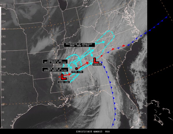
Shows the relationship between the surface and upper lows and how moisture from the surface low is being thrown back into the cold air associated wih the upper low, producing the heavy snow.
Category: Alabama's Weather, Winter Weather
About the Author (Author Profile)
Bill Murray is the President of The Weather Factory. He is the site's official weather historian and a weekend forecaster. He also anchors the site's severe weather coverage. Bill Murray is the proud holder of National Weather Association Digital Seal #0001 @wxhistorianSubscribe
If you enjoyed this article, subscribe to receive more just like it.


