Snow Ending From West To East
**No afternoon Weather Xtreme video due to ongoing weather issues**
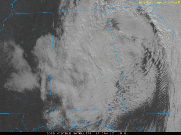
SNOW MOVES OUT LATE THIS AFTERNOON: Snow has ended in Tuscaloosa and points west, and clearing will follow rather quickly. See the visible satellite image below…
A band of heavy snow is moving through the Birmingham metro as I write this at 1:30… making the grassy areas white. This final band of heavier snow will move through Anniston and Gadsden between 3:00 and 5:00 this afternoon. The sky will become clear statewide tonight.
ACCUMULATION: Readers of the blog know I have been warning, and almost promising a surprise or two with the cold core upper low that is moving through Alabama this afternoon, which looks like this on a 500 mb chart…
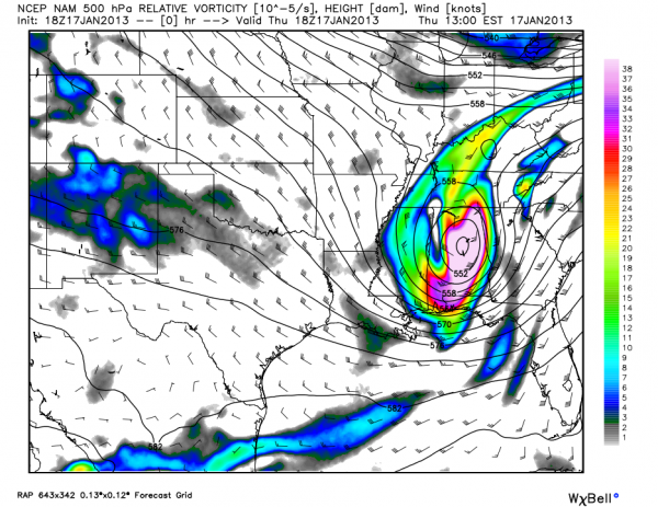
We don’t have much skill in dealing with snow placement and amounts in these situations.
The clear surprise is that it looks like the heavier snow amounts will be over Northwest Alabama, as opposed to Northeast Alabama. Of course, the event isn’t over just yet, but it looks like the biggest snow totals are going to be over Tuscaloosa, Pickens, Marion, Lamar, Fayette, Winston, Cullman, and Walker Counties. Most snow totals in this region are at 2 inches, although we have seen isolated amounts to 3 inches. This is the 2-3″ heavier snow zone we expected over on the other side of the state across higher terrain.
TRAVEL: The snow came down so hard and so fast (and yes, we have had convective snow with thunder and lightning over parts of Cullman and Walker Counties) that despite temperatures in the mid 30s, snow has covered roads over Northwest Alabama. These counties have “slushy” roads right now, and accidents have been reported…
Pickens, Tuscaloosa, Lamar, Fayette, Marion, Winston, Walker, Cullman
The good news is that road conditions will improve dramatically once the snow stops over the next hour. In fact, there is a chance the sun breaks out before dawn helping to melt the snow away. But, for the next hour or two, be aware that driving is tricky in these counties; just take it slow and easy.
We understand the heavy snow band coming through Birmingham is putting down slush now over the northern part of Jefferson County, so be careful if traveling there. For most of the rest of the “snow zone”, the roads are just wet, and accumulation is light and in grassy areas.
Later tonight, temperatures will go below freezing, and any moisture that lingers will have the potential to turn into ice, and “black ice” patches are very possible, especially after 9:00. The good news is that most of the moisture will quickly evaporate; looking at roads over in Mississippi they are dry as a bone, even where heavier snow came down earlier today.
TOMORROW THROUGH SUNDAY: Finally, a string of sunny days. Highs mostly in the 50s, lows mostly in the 30s.
Global models have backed off the depth of the cold air coming in next week; highs look to be in the 40s and lows in the 20s Monday and Tuesday; coldest morning will be early Tuesday with a low in the 20-25 degree range, along with teens for the colder valleys.
WEATHER BRAINS: Don’t forget you can listen to our weekly 90 minute netcast anytime on the web, or on iTunes. This is the show all about weather featuring many familiar voices, including our meteorologists here at ABC 33/40.
CONNECT: You can find me on all of the major social networks…
Look for the next Weather Xtreme video here by 7:00 a.m. tomorrow…
Category: Alabama's Weather
About the Author (Author Profile)
James Spann is one of the most recognized and trusted television meteorologists in the industry. He holds the AMS CCM designation and television seals from the AMS and NWA. He is a past winner of the Broadcast Meteorologist of the Year from both professional organizations.Subscribe
If you enjoyed this article, subscribe to receive more just like it.


