The January 19, 2008 Saturday Snow
Bringing together the ingredients for snow in Central Alabama is difficult. Even when the ingredients look to be coming together, it is difficult to make an excellent forecast.
For nearly a week back in January 2008, the computer models had been suggesting that there might be a wintry precipitation event in Alabama. By Thursday, January 17th, they began to come together with the idea that a significant snow would affect the middle part of the state.
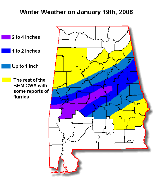
By Friday morning the 18th, winter storm watches were issued. Predictions by Friday afternoon were that a swath across Central Alabama would pick up 3-6 inches of snow, with a wider area perhaps getting 2-4 inches. One to two inches was predicted for areas north and south of the heavier snow.
Precipitation began breaking out late on Friday evening as a low pressure system spun up in the Gulf of Mexico. Initially, surface temperatures were in the upper 30s and lower 40s, but dewpoints were in the teens and twenties. Evaporational cooling pulled the readings down to the middle 30s. A layer of colder air just below 5,000 feet allowed the melted snowflakes to refreeze into sleet and there were many reports of sleet and a wintry mix over Central sections of Alabama overnight.
But most areas awakened on Saturday morning to no snow on the ground and profound disappointment.
For many, however, their desires would be fueled by a surge of moisture from the low south of the Louisiana coast. Snow spread quickly over parts of the Heavy Snow warning area. Places across South Central Alabama that rarely see snow at all celebrated as the white stuff came down.
Flurries were reported in the city of Birmingham, but officially, the total for the day at the Airport was zero, not even a trace. The city had just celebrated the end of its record breaking seven year snowless streak the previous March.
But in places like Shelby County, children under nine years old saw something they had never seen in their lives: an accumulating snow. They celebrated joyously at the sight of any at all.
A band of average 2-4 inch amounts extended from Marengo County through southern Hale, much of Perry, Dallas, much of Chilton and Coosa Counties. The highest accumulations were in Dallas County, where up to five inches as reported at Orrville.
Over two inches was reported in Sumter County, with two inches in Marengo County at Linden. Other amounts included four inches at Toxey in Choctaw County, 3 inches at Thomasville in Clarke County and 2.5 inches at Butler in Choctaw County. An inch fell as far south as Chatom in Washington County.
The snow was mostly melted by nightfall.
Category: Met 101/Weather History
About the Author (Author Profile)
Bill Murray is the President of The Weather Factory. He is the site's official weather historian and a weekend forecaster. He also anchors the site's severe weather coverage. Bill Murray is the proud holder of National Weather Association Digital Seal #0001 @wxhistorianSubscribe
If you enjoyed this article, subscribe to receive more just like it.


