Some Freezing Rain Early Friday?
An all new edition of the ABC 33/40 Weather Xtreme video is available in the player on the right sidebar of the blog. You can subscribe to the Weather Xtreme video on iTunes by clicking here.
RIGHT NOW: The sky is generally cloudy over much of Alabama this afternoon, but the overcast is thin enough for a little sunshine to get through. Temperatures are in the 50s, and there is no rain on radar.
TONIGHT/TOMORROW: A cold front will ease into North Alabama tonight, and could squeeze out a little rain, or a few sprinkles as it passes through. But, with only limited moisture rain amounts will be very light and spotty.
There will be a big temperature contrast across Alabama tomorrow as the front stalls around U.S. 80. South of the front, the high will be well into the 60s, but north of the front, the high tomorrow will be only in the 40s. In fact, a few places near the Tennessee border might have a hard time getting out of the 30s.
ICING ISSUES? Precipitation will move into Alabama tomorrow night, and surface temperatures will be very close to freezing, setting up the potential for a little freezing rain late tomorrow night and very early Friday morning. Remember, freezing rain is rain that falls in liquid form with surface temperatures at or below freezing. This can lead to some ice accumulation on exposed surfaces.
Based on the morning models, we believe the greatest risk of freezing rain will be east of a line from Athens to Gadsden to Anniston to Roanoke, and mainly form about midnight tomorrow night through 7:00 a.m. Friday.
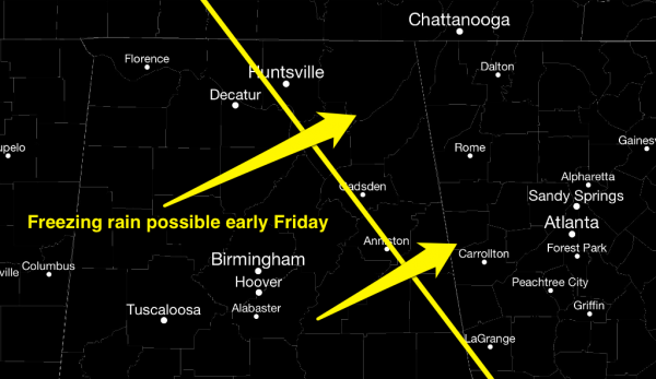
Keep in mind there could be a little bridge icing in this part of Alabama early Friday morning, thankfully temperatures should rise above freezing by mid-morning, and the travel issues won’t last long. See the Weather Xtreme video for detailed maps and more information.
Otherwise, Friday will be cloudy with periods of rain, with an afternoon high in the low to mid 50s. Rain amounts should be generally one-half inch or less.
THE ALABAMA WEEKEND: We project a cool, dry weekend for the state. The high Saturday will be in the 47-51 degree range, followed by a high in the mid 50s Sunday. Early mornings will be cold, with lows below freezing. Both days will feature a mix of sun and clouds.
NEXT WEEK: Yet another weather issue; SPC has put Arkansas in a severe weather risk for Tuesday, and we will have to watch a deep upper trough over the Southwest U.S. for potential for strong to severe storms around here by Wednesday. There is no way of resolving the details now, but a significant rain/storm event seems like Wednesday, and with surface temperatures warming well into the 60s prior to the arrival of the storm system, it looks like there could be a decent amount of instability involved. See the Weather Xtreme video for more details and the maps.
WEATHER BRAINS: Don’t forget you can listen to our weekly 90 minute netcast anytime on the web, or on iTunes. This is the show all about weather featuring many familiar voices, including our meteorologists here at ABC 33/40.
CONNECT: You can find me on all of the major social networks…
I had a great time today visiting with the 3rd graders at Alberta Elementary in Tuscaloosa, and the 2nd graders at Briarwood Christian School in Birmingham. Be looking for them on the Pepsi KIDCAM today at 5:00 and 6:00 on ABC 33/40 News! The next Weather Xtreme video will be posted here by 7:00 a.m. tomorrow….
Category: Alabama's Weather
About the Author (Author Profile)
James Spann is one of the most recognized and trusted television meteorologists in the industry. He holds the AMS CCM designation and television seals from the AMS and NWA. He is a past winner of the Broadcast Meteorologist of the Year from both professional organizations.Subscribe
If you enjoyed this article, subscribe to receive more just like it.


