

Significant Severe Weather Threat Early Tomorrow
An all new edition of the ABC 33/40 Weather Xtreme video is available in the player on the right sidebar of the blog. You can subscribe to the Weather Xtreme video on iTunes by clicking here.
Be sure and watch the Weather Xtreme video for the maps and graphics that go along with this discussion….
RIGHT NOW: It is a warm and breezy January day across Alabama this afternoon. The sky is generally cloudy with a few peeks of sunshine. Montgomery has soared to a balmy 78 degrees at Montgomery; Tuscaloosa is at 74, Anniston 72, and Birmingham 70 degrees at 3:00. The radar is relatively quiet across our state, but things are lightning up like a Christmas tree to the west.
Winds are increasing out of the south; they will average 15-30 mph tonight, with occasionally higher gusts.
Severe thunderstorm and tornado watches are up from Central Texas to near St. Louis, and tornado warnings are up for counties in Arkansas between Fort Smith and Fayetteville, and in Missouri west of St. Louis as I write this. SPC maintains an enhanced “moderate” risk of severe weather for areas just west of Alabama through tonight, and the standard “slight” risk runs all the way from Texas to near Chicago and Indianapolis.
THE ALABAMA SEVERE WEATHER SITUATION: The morning model runs are a tad slower, and quite frankly, at this stage of the game, I just prefer to look at satellite and radar trends to get a feel for what happens here. And, we will need to adjust the timing a bit. Below is a graphic prepared by the NWS in Birmingham, which looks good here.
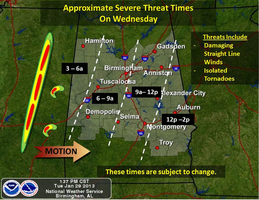
Note this map shows only the counties served by the Birmingham National Weather Service forecast office; understand all 67 Alabama counties will have a risk of severe weather.
Bottom line is that this will be a 3:00 a.m. to 12:00 noon event for North-Central Alabama. Initially, the storms will impact the northwest counties, then moving steadily to the east.
THREATS: There is growing concern that cells can form ahead of the main line; we are seeing that in some of the mesoscale models. Any discrete cells that form ahead of the main line will have the potential to produce a tornado, as there will be a high degree of storm relative helicity (veering of the wind with altitude in relation to storm motion) in place, and the air will be pretty unstable for late January (surface based CAPE values over 500 j/kg).
And, clearly there is great potential for damaging winds along the main QLCS (quasi linear convective system). The low level jet, about 5,000 feet off the ground, will be screaming with winds of 60-70 knots; some of this will transfer down to the surface. I have concern there will be considerable tree and power line damage with this feature tomorrow morning. And, also some potential for structural damage. Honestly, I would not want to be in a mobile home when the main line passes through tomorrow morning.
I encourage you to take severe thunderstorm warnings seriously tomorrow morning, and pretty much carry out a plan of action as if it was a tornado warning.
The rain will be heavy along the main line; we project average rain amounts of one inch; isolated amounts to 2 inches are possible where multiple storms develop. The PW (precipitable water) values will be unusually high for winter with this event. But, we don’t expect widespread flooding issues.
CALL TO ACTION: Be sure you have a good, working, and properly programmed NOAA Weather Radio with fresh batteries for warnings that might come while your family is asleep. NEVER rely on a siren to receive severe weather warnings; they are horribly inaffective and reach only a small number of people outdoors. See the ABC 33/40 “Do You Have A Plan” section for a three step process on getting ready for this kind of severe weather event.
Storms will end from west to east during the midday hours tomorrow, and temperatures will fall into the 50s during the afternoon hours as cooler and more stable air moves into the state.
THURSDAY/FRIDAY: These days will be cool and dry. The high will be close to 50, and lows will be at or below freezing. The 12Z model runs are colder, suggesting we will see upper 20s early Friday, and mid 20s at daybreak Saturday.
OUR WEEKEND: Mostly dry, although a cold front passing through Saturday night might squeeze out a sprinkle in spots. Highs should be in the 50s Saturday and Sunday.
Dry weather should linger into early next week; see the Weather Xtreme video for more long range ideas.
WEATHER BRAINS: Don’t forget you can listen to our weekly 90 minute netcast anytime on the web, or on iTunes. This is the show all about weather featuring many familiar voices, including our meteorologists here at ABC 33/40. Scroll down for the show notes on this week’s new episode we recorded last night.
CONNECT: You can find me on all of the major social networks…
I had a great time today visiting with the senior adults at Sylvan Springs; look for updates here on the blog through the night as the system to the west gets closer…
Category: Alabama's Weather
About the Author (Author Profile)
James Spann is one of the most recognized and trusted television meteorologists in the industry. He holds the AMS CCM designation and television seals from the AMS and NWA. He is a past winner of the Broadcast Meteorologist of the Year from both professional organizations.Subscribe
If you enjoyed this article, subscribe to receive more just like it.


