Looking West
Click image to enlarge.
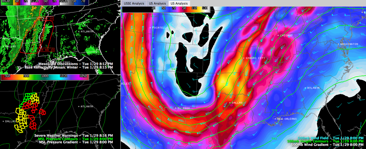
ON THE SURFACE MAP
We have a 998 millibar surface low just north of Texarkana, Arkansas. South and southeasterly winds are averaging 7-14 mph with occasional higher gusts across Alabama. To the west, over Mississippi, they are stronger since they are closer to the low, averaging 10-20 mph with higher gusts. At West Memphis AR, they are southerly at 18 mph gusting to 30 mph.
WATCHES
Tornado watches cover nearly all of Arkansas, northeastern Texas, extreme southeastern Oklahoma, northern Louisiana, extreme western Mississippi, as well as southeastern Missouri, extreme western Kentucky and southern Illinois.
UP IN THE ATMOSPHERE
…Intense upper trough moving across Teas now. Strong winds over 100 mph at 18,000 feet are moving across northeastern Texas, Arkansas and into western Tennessee now and will be pushing into western Mississippi and northern Louisiana over the next few hours.
INSTABILITY SHOWERS OVER ALABAMA
Meager instability is in place now across the southwestern quarter of Alabama. This has allowed showers to form from Clarke and Marengo Counties north northeastward through Hale, Tuscaloosa and into Cullman Counties. The CAPE at Birmingham at 6 p.m. was 142 j/kg. There was a tiny bit of a cap. That inversion will prevent those showers from growing very much for a while.
SUPERCELLS OVER THE DELTA
…A few storms showing supercellular characteristics are along and just east of the Mississippi River over the Delta. They have had tornado warnings on them, back around Greenville and Indianola. They have since dropped below severe limits.
…Look for either a new tornado watch or an extension of the existing one into Central and northern Mississippi as well as western Tennessee shortly as instability increases over that area.
ARKANSAS/LOUISIANA STORMS OF CONCERN
…The storms that extend from near Little Rock to I-20 near Ruston LA then to west of Alexandria then to north of Lake Charles are growing stronger. CAPEs are 1000-2000 j/kg ahead of these storms. Bulk wind shear numbers are 50-60 knots and 0-1 km storm relative helicities are over 450 m2/s2.
…These storms will intensify and move into Mississippi over the next few hours. They will be severe and have the capability to produce tornadoes.
…Here is a live stream from KATV: https://www.katv.com/category/210559/live-stream
MAIN LINE
…The main line of storms extends from from Chicago to east of Kansas City to east of Tyler to west of College Station. There are several reports of trees down from along the line in northeastern Texas. Severe thunderstorm warnings blanket the area ahead of the line over northeastern Texas.
…CHECKING IN WITH NWS OFFICES…
SHREVEPORT
…Numerous trees down in Smith County, Texas, which is where Tyler is located. This is associated with the main squall line.
…Unconfirmed report of injuries in Cass County, TX. Mobile homes flipped over.
…The NWS Shreveport radar is going through the Dual Pol upgrade right now and is operating in a degraded mode. They are using surrounding radars to provide coverage.
LITTLE ROCK
…Four tornado warnings in the state now…one north of Hot Springs, one east of Little Rock, one that includes Pine Bluff and another east of ElDorado.
…Only one report of a tornado in Arkansas so far. It was just after 3 p.m. in the northwest corner of the state.
MEMPHIS
…The NWS Memphis is still experiencing some problems with their NOAA WeatherRadio system.
JACKSON
…Alan Gerard and his team are busy tracking those cells over the Delta.
…Just had a tree on a house and fire reported at a church in Leland.
FOR ALABAMA
Watching several things tonight for us in Alabama:
…We will continue to watch for the instability to ramp up over Alabama in the next few hours and monitoring the cap. I don’t expect any problems in Alabama over the next few hours, but we will be watching.
…we will continue to monitor the development over the Mississippi Delta. It could impacts extreme northwestern Alabama later tonight around 2:30 a.m.
…also carefully watching what happens with the activity over Arkansas and Louisiana to see if it holds together. Indications are that it might get overtaken by the main line in the hours before sunrise, pushing into West Alabama’s Marion County around 5-6 a.m., Tuscaloosa around 7:30 and Birmingham around 9-10 a.m. The storms could intensify as they move into areas along and east of I-65 during the late morning and early afternoon before moving out of the Auburn area into Georgia around 4 p.m.
…Winds will continue to increase through the overnight, averaging 25 mph later, and gusting to over 35 mph at times through tomorrow. Some eastern Alabama locations could see gusts to 50 mph.
…western counties should see 0.75-1.00 inch of rain, ranging up to 1.50 inches over eastern Alabama.
TIMES ARE ESTIMATES
…Please be aware that the times we are quoting are based on the best information we have. Things will become clearer as the storms get into Mississippi and we can tell what mode they will exhibit and start getting some time estimates down.
Category: Alabama's Weather, Severe Weather
About the Author (Author Profile)
Bill Murray is the President of The Weather Factory. He is the site's official weather historian and a weekend forecaster. He also anchors the site's severe weather coverage. Bill Murray is the proud holder of National Weather Association Digital Seal #0001 @wxhistorianSubscribe
If you enjoyed this article, subscribe to receive more just like it.


